Havre geodata
Havre (Montana) is a seat of a second-order administrative division; located in United States in America/Denver (GMT-6) time zone. With population of 9,834 people, there are 4515 cities with bigger population in this country. Compared to other cities in United States, 99.2% of cities are located further ↓South; 85.6% of cities are located further →East and 91.7% of cities have lower elevation than Havre. Note1


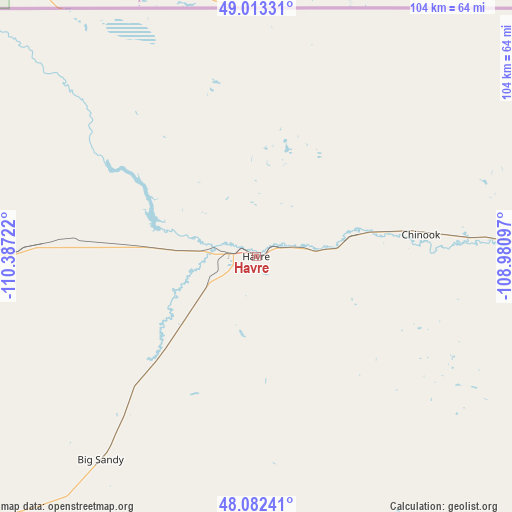
Havre GPS coordinates[2]
48° 33' 0" North, 109° 41' 2.724" West
| Map corner | latitude | longitude |
|---|---|---|
| Upper-left | 49.01331°, | -110.38722° |
| Center: | 48.55°, | -109.68409° |
| Lower-right: | 48.08241°, | -108.98097° |
| Map W x H: | 103.5×103.5 km | = 64.3×64.3mi |
| max Lat: | 71.29058° ⇑0.8% North |
| Havre: | 48.55° |
| min Lat: | ⇓99.2% South 19.06759° |
| min Long | Havre | max Long |
| -171.73463° | -109.68409° | -66.98998° |
| W 14.4%⇐ | ⇒85.6% E |
Elevation
Elevation of Havre is 770 m = 2526 ft, and this is 475.2 m = 1559 ft above average elevation for this country.
| Max E: |
3189 m = 10463 ft | 8.3% |
| Havre | 770 m 2526 ft | |
| Avg. | 294.8 m = 967 ft | |
Min E: |
-60 m = -197 ft | 91.7% |
See also: United States elevation on elevation.city.
Geographical zone
Havre is located in North temperate zone (between Tropic of Cancer and the Arctic Circle). Distance of this North polar circle is 2002.9 km =1244.5 mi to North.| Distance of | km | miles | from Havre |
|---|---|---|---|
| North Pole | 4608.8 | 2863.8 | to North |
| Arctic Circle | 2002.9 | 1244.5 | to North |
| Tropic Cancer | 2792.3 | 1735.1 | to South |
| Equator | 5398.3 | 3354.3 | to South |


Nearby cities:
15 places around Havre: (largest is in red/bold)
• Belt
159 km =98.8 mi,  215°
215°
• Big Sandy
52 km =32.3 mi, 217°
• Black Eagle
164.4 km =102.2 mi,  226°
226°
• Chester
94.6 km =58.8 mi,  267°
267°
• Chinook
33.6 km =20.9 mi,  82°
82°
• Fort Belknap Agency
68.1 km =42.3 mi,  96°
96°
• Fort Benton
109.2 km =67.9 mi, 221°
• Harlem
66.3 km =41.2 mi,  91°
91°
• Havre North
1.7 km =1.1 mi,  33°
33°
• Hays
96.2 km =59.8 mi,  130°
130°
• Lewistown
166.5 km =103.5 mi,  173°
173°
• Malmstrom Air Force Base
161 km =100 mi, 223°
• Malta
135.1 km =83.9 mi, 99°
• Shelby
160.1 km =99.5 mi, 268°
• Stanford
160.3 km =99.6 mi,  194°
194°
Sources, notices
• [Note1] Compared only with cities in United States existing in our database
• [Src1] Map data: © OpenStreetMap contributors (CC-BY-SA)
• [Src2] Other city data from geonames.org with taken over terms of usage.
• [Src3] Geographical zone / Annual Mean Temperature by Robert A. Rohde @ Wikipedia
