Roundup geodata
Roundup (Montana) is a seat of a second-order administrative division; located in United States in America/Denver (GMT-6) time zone. With population of 1,836 people, there are 12418 cities with bigger population in this country. Compared to other cities in United States, 95.7% of cities are located further ↓South; 85.2% of cities are located further →East and 93.3% of cities have lower elevation than Roundup. Note1


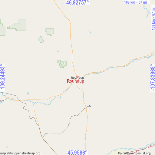
Roundup GPS coordinates[2]
46° 26' 42.864" North, 108° 32' 30.48" West
| Map corner | latitude | longitude |
|---|---|---|
| Upper-left | 46.92757°, | -109.24493° |
| Center: | 46.44524°, | -108.5418° |
| Lower-right: | 45.9586°, | -107.83868° |
| Map W x H: | 107.7×107.7 km | = 66.9×66.9mi |
| max Lat: | 71.29058° ⇑4.3% North |
| Roundup: | 46.44524° |
| min Lat: | ⇓95.7% South 19.06759° |
| min Long | Roundup | max Long |
| -171.73463° | -108.5418° | -66.98998° |
| W 14.8%⇐ | ⇒85.2% E |
Elevation
Elevation of Roundup is 979 m = 3212 ft, and this is 684.2 m = 2245 ft above average elevation for this country.
| Max E: |
3189 m = 10463 ft | 6.7% |
| Roundup | 979 m 3212 ft | |
| Avg. | 294.8 m = 967 ft | |
Min E: |
-60 m = -197 ft | 93.3% |
See also: United States elevation on elevation.city.
Geographical zone
Roundup is located in North temperate zone (between Tropic of Cancer and the Arctic Circle). Distance of this North polar circle is 2236.9 km =1389.9 mi to North.| Distance of | km | miles | from Roundup |
|---|---|---|---|
| North Pole | 4842.8 | 3009.2 | to North |
| Arctic Circle | 2236.9 | 1389.9 | to North |
| Tropic Cancer | 2558.3 | 1589.7 | to South |
| Equator | 5164.2 | 3208.9 | to South |


Nearby cities:
15 places around Roundup: (largest is in red/bold)
• Billings
73.7 km =45.8 mi,  177°
177°
• Columbus
105.3 km =65.4 mi,  211°
211°
• Hardin
106.9 km =66.4 mi,  137°
137°
• Harlowton
99 km =61.5 mi,  269°
269°
• Hysham
101.7 km =63.2 mi,  99°
99°
• Joliet
111.8 km =69.5 mi,  197°
197°
• Laurel
88.1 km =54.7 mi,  191°
191°
• Lewistown
96.3 km =59.8 mi,  315°
315°
• Lockwood
70.3 km =43.7 mi,  172°
172°
• Park City
94.9 km =59 mi, 197°
• Pryor
112.9 km =70.2 mi, 179°
• Ryegate
57.4 km =35.7 mi,  253°
253°
• Shepherd
57.9 km =36 mi,  164°
164°
• Winnett
63.7 km =39.6 mi,  13°
13°
• Worden
61.4 km =38.2 mi,  151°
151°
Sources, notices
• [Note1] Compared only with cities in United States existing in our database
• [Src1] Map data: © OpenStreetMap contributors (CC-BY-SA)
• [Src2] Other city data from geonames.org with taken over terms of usage.
• [Src3] Geographical zone / Annual Mean Temperature by Robert A. Rohde @ Wikipedia
