Laurel geodata
Laurel (Montana) is a populated place; located in United States in America/Denver (GMT-6) time zone. With population of 6,943 people, there are 5850 cities with bigger population in this country. Compared to other cities in United States, 94.5% of cities are located further ↓South; 85.3% of cities are located further →East and 93.4% of cities have lower elevation than Laurel. Note1


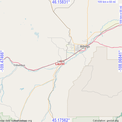
Laurel GPS coordinates[2]
45° 40' 8.832" North, 108° 46' 17.508" West
| Map corner | latitude | longitude |
|---|---|---|
| Upper-left | 46.15831°, | -109.47466° |
| Center: | 45.66912°, | -108.77153° |
| Lower-right: | 45.17562°, | -108.06841° |
| Map W x H: | 109.3×109.3 km | = 67.9×67.9mi |
| max Lat: | 71.29058° ⇑5.5% North |
| Laurel: | 45.66912° |
| min Lat: | ⇓94.5% South 19.06759° |
| min Long | Laurel | max Long |
| -171.73463° | -108.77153° | -66.98998° |
| W 14.7%⇐ | ⇒85.3% E |
Elevation
Elevation of Laurel is 1006 m = 3301 ft, and this is 711.2 m = 2333 ft above average elevation for this country.
| Max E: |
3189 m = 10463 ft | 6.6% |
| Laurel | 1006 m 3301 ft | |
| Avg. | 294.8 m = 967 ft | |
Min E: |
-60 m = -197 ft | 93.4% |
See also: United States elevation on elevation.city.
Geographical zone
Laurel is located in North temperate zone (between Tropic of Cancer and the Arctic Circle). Distance of this North polar circle is 2323.2 km =1443.6 mi to North.| Distance of | km | miles | from Laurel |
|---|---|---|---|
| North Pole | 4929.1 | 3062.8 | to North |
| Arctic Circle | 2323.2 | 1443.6 | to North |
| Tropic Cancer | 2472 | 1536 | to South |
| Equator | 5077.9 | 3155.3 | to South |


Nearby cities:
15 places around Laurel: (largest is in red/bold)
• Absarokee
54.8 km =34.1 mi,  252°
252°
• Billings
24.6 km =15.3 mi,  58°
58°
• Bridger
43 km =26.7 mi,  194°
194°
• Columbus
37.5 km =23.3 mi,  264°
264°
• Cowley
90.5 km =56.2 mi,  164°
164°
• Hardin
90.3 km =56.1 mi,  85°
85°
• Joliet
25.6 km =15.9 mi,  217°
217°
• Lockwood
32.3 km =20.1 mi, 58°
• Park City
12.1 km =7.5 mi, 250°
• Pryor
32.5 km =20.2 mi,  145°
145°
• Red Lodge
65.3 km =40.6 mi,  214°
214°
• Roundup
88.1 km =54.7 mi,  11°
11°
• Ryegate
79.3 km =49.3 mi,  331°
331°
• Shepherd
45.1 km =28 mi,  47°
47°
• Worden
57.3 km =35.6 mi, 55°
Sources, notices
• [Note1] Compared only with cities in United States existing in our database
• [Src1] Map data: © OpenStreetMap contributors (CC-BY-SA)
• [Src2] Other city data from geonames.org with taken over terms of usage.
• [Src3] Geographical zone / Annual Mean Temperature by Robert A. Rohde @ Wikipedia
