Mott geodata
Mott (North Dakota) is a seat of a second-order administrative division; located in United States in America/Denver (GMT-6) time zone. With population of 793 people, there are 17876 cities with bigger population in this country. Compared to other cities in United States, 95.6% of cities are located further ↓South; 82% of cities are located further →East and 91.2% of cities have lower elevation than Mott. Note1


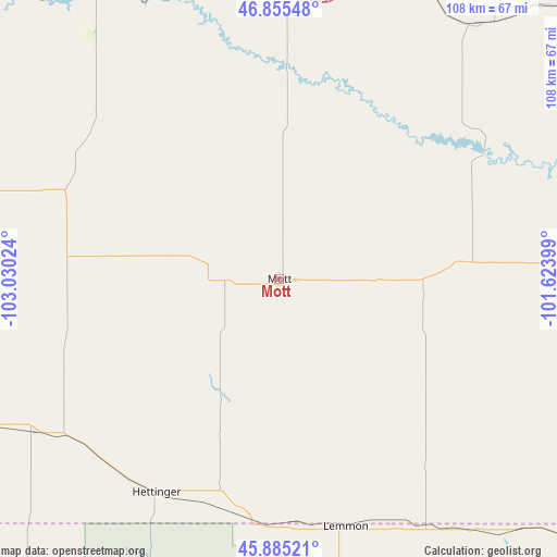
Mott GPS coordinates[2]
46° 22' 21" North, 102° 19' 37.596" West
| Map corner | latitude | longitude |
|---|---|---|
| Upper-left | 46.85548°, | -103.03024° |
| Center: | 46.3725°, | -102.32711° |
| Lower-right: | 45.88521°, | -101.62399° |
| Map W x H: | 107.9×107.9 km | = 67×67mi |
| max Lat: | 71.29058° ⇑4.4% North |
| Mott: | 46.3725° |
| min Lat: | ⇓95.6% South 19.06759° |
| min Long | Mott | max Long |
| -171.73463° | -102.32711° | -66.98998° |
| W 18%⇐ | ⇒82% E |
Elevation
Elevation of Mott is 726 m = 2382 ft, and this is 431.2 m = 1415 ft above average elevation for this country.
| Max E: |
3189 m = 10463 ft | 8.8% |
| Mott | 726 m 2382 ft | |
| Avg. | 294.8 m = 967 ft | |
Min E: |
-60 m = -197 ft | 91.2% |
See also: United States elevation on elevation.city.
Geographical zone
Mott is located in North temperate zone (between Tropic of Cancer and the Arctic Circle). Distance of this North polar circle is 2245 km =1395 mi to North.| Distance of | km | miles | from Mott |
|---|---|---|---|
| North Pole | 4850.9 | 3014.2 | to North |
| Arctic Circle | 2245 | 1395 | to North |
| Tropic Cancer | 2550.2 | 1584.6 | to South |
| Equator | 5156.1 | 3203.9 | to South |


Nearby cities:
15 places around Mott: (largest is in red/bold)
• Amidon
77.2 km =48 mi,  279°
279°
• Belfield
87.7 km =54.5 mi,  310°
310°
• Bison
95.3 km =59.2 mi,  186°
186°
• Bowman
84.7 km =52.6 mi,  255°
255°
• Carson
58.7 km =36.5 mi,  85°
85°
• Dickinson
66.5 km =41.3 mi,  327°
327°
• Elgin
37.1 km =23.1 mi,  84°
84°
• Glen Ullin
62.2 km =38.6 mi,  37°
37°
• Hebron
62.5 km =38.8 mi,  20°
20°
• Hettinger
47.7 km =29.6 mi,  210°
210°
• Lemmon
49.7 km =30.9 mi,  164°
164°
• McIntosh
90.5 km =56.2 mi,  123°
123°
• New England
45.4 km =28.2 mi,  294°
294°
• New Salem
87.5 km =54.4 mi,  53°
53°
• Richardton
56.9 km =35.4 mi,  0°
0°
Sources, notices
• [Note1] Compared only with cities in United States existing in our database
• [Src1] Map data: © OpenStreetMap contributors (CC-BY-SA)
• [Src2] Other city data from geonames.org with taken over terms of usage.
• [Src3] Geographical zone / Annual Mean Temperature by Robert A. Rohde @ Wikipedia
