Amidon geodata
Amidon (North Dakota) is a seat of a second-order administrative division; located in United States in America/Denver (GMT-6) time zone. With population of 21 people, there are 21053 cities with bigger population in this country. Compared to other cities in United States, 95.8% of cities are located further ↓South; 82.4% of cities are located further →East and 92.6% of cities have lower elevation than Amidon. Note1


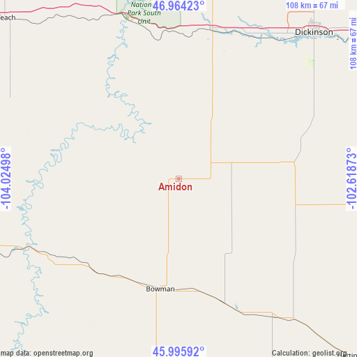
Amidon GPS coordinates[2]
46° 28' 56.028" North, 103° 19' 18.66" West
| Map corner | latitude | longitude |
|---|---|---|
| Upper-left | 46.96423°, | -104.02498° |
| Center: | 46.48223°, | -103.32185° |
| Lower-right: | 45.99592°, | -102.61873° |
| Map W x H: | 107.7×107.7 km | = 66.9×66.9mi |
| max Lat: | 71.29058° ⇑4.2% North |
| Amidon: | 46.48223° |
| min Lat: | ⇓95.8% South 19.06759° |
| min Long | Amidon | max Long |
| -171.73463° | -103.32185° | -66.98998° |
| W 17.6%⇐ | ⇒82.4% E |
Elevation
Elevation of Amidon is 885 m = 2904 ft, and this is 590.2 m = 1936 ft above average elevation for this country.
| Max E: |
3189 m = 10463 ft | 7.4% |
| Amidon | 885 m 2904 ft | |
| Avg. | 294.8 m = 967 ft | |
Min E: |
-60 m = -197 ft | 92.6% |
See also: United States elevation on elevation.city.
Geographical zone
Amidon is located in North temperate zone (between Tropic of Cancer and the Arctic Circle). Distance of this North polar circle is 2232.8 km =1387.4 mi to North.| Distance of | km | miles | from Amidon |
|---|---|---|---|
| North Pole | 4838.7 | 3006.6 | to North |
| Arctic Circle | 2232.8 | 1387.4 | to North |
| Tropic Cancer | 2562.4 | 1592.2 | to South |
| Equator | 5168.3 | 3211.4 | to South |


Nearby cities:
15 places around Amidon: (largest is in red/bold)
• Baker
74.9 km =46.5 mi,  260°
260°
• Beach
71.1 km =44.2 mi,  312°
312°
• Belfield
45.8 km =28.5 mi,  11°
11°
• Bowman
33.7 km =20.9 mi,  189°
189°
• Buffalo
101.3 km =62.9 mi, 189°
• Dickinson
60 km =37.3 mi,  42°
42°
• Hettinger
75.1 km =46.7 mi,  135°
135°
• Killdeer
107.9 km =67 mi,  23°
23°
• Lemmon
107.8 km =67 mi,  123°
123°
• Manning
93.1 km =57.8 mi,  26°
26°
• Medora
50.4 km =31.3 mi,  342°
342°
• Mott
77.2 km =48 mi,  99°
99°
• New England
35.3 km =21.9 mi,  79°
79°
• Richardton
88.8 km =55.2 mi,  59°
59°
• Wibaux
86.5 km =53.7 mi, 310°
Sources, notices
• [Note1] Compared only with cities in United States existing in our database
• [Src1] Map data: © OpenStreetMap contributors (CC-BY-SA)
• [Src2] Other city data from geonames.org with taken over terms of usage.
• [Src3] Geographical zone / Annual Mean Temperature by Robert A. Rohde @ Wikipedia
