Hillsboro geodata
Hillsboro (Oregon) is a seat of a second-order administrative division; located in United States in America/Los_Angeles (GMT-7) time zone. With population of 102,347 people, there are 340 cities with bigger population in this country. Compared to other cities in United States, 94.1% of cities are located further ↓South; 97.8% of cities are located further →East and 77.3% of cities have higher elevation than Hillsboro. Note1


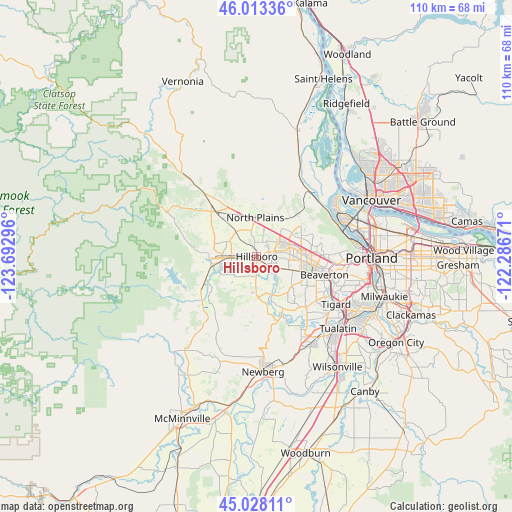
Hillsboro GPS coordinates[2]
45° 31' 22.404" North, 122° 59' 23.388" West
| Map corner | latitude | longitude |
|---|---|---|
| Upper-left | 46.01336°, | -123.69296° |
| Center: | 45.52289°, | -122.98983° |
| Lower-right: | 45.02811°, | -122.28671° |
| Map W x H: | 109.5×109.5 km | = 68×68mi |
| max Lat: | 71.29058° ⇑5.9% North |
| Hillsboro: | 45.52289° |
| min Lat: | ⇓94.1% South 19.06759° |
| min Long | Hillsboro | max Long |
| -171.73463° | -122.98983° | -66.98998° |
| W 2.2%⇐ | ⇒97.8% E |
Elevation
Elevation of Hillsboro is 59 m = 194 ft, and this is 235.8 m = 774 ft below average elevation for this country.
| Max E: |
3189 m = 10463 ft | 77.3% |
| Avg. | 294.8 m = 967 ft | |
| Hillsboro | 59 m = 194 ft | |
Min E: |
-60 m = -197 ft | 22.7% |
See also: Hillsboro elevation on elevation.city.
Geographical zone
Hillsboro is located in North temperate zone (between Tropic of Cancer and the Arctic Circle). Distance of this North polar circle is 2339.5 km =1453.7 mi to North.| Distance of | km | miles | from Hillsboro |
|---|---|---|---|
| North Pole | 4945.4 | 3072.9 | to North |
| Arctic Circle | 2339.5 | 1453.7 | to North |
| Tropic Cancer | 2455.8 | 1526 | to South |
| Equator | 5061.7 | 3145.2 | to South |


Nearby cities:
15 places around Hillsboro: (largest is in red/bold)
• Aloha
10.1 km =6.3 mi,  108°
108°
• Banks
14.4 km =8.9 mi,  317°
317°
• Beaverton
15 km =9.3 mi, 105°
• Bethany
10.3 km =6.4 mi,  67°
67°
• Cedar Hills
15 km =9.3 mi,  97°
97°
• Cedar Mill
13.9 km =8.6 mi,  89°
89°
• Cornelius
5.5 km =3.4 mi,  266°
266°
• Forest Grove
9.4 km =5.8 mi, 267°
• Gaston
15.1 km =9.4 mi,  230°
230°
• North Plains
8.3 km =5.2 mi,  358°
358°
• Oak Hills
11.8 km =7.3 mi,  80°
80°
• Rockcreek
9.3 km =5.8 mi, 70°
• West Haven
17.2 km =10.7 mi, 91°
• West Haven-Sylvan
17.3 km =10.7 mi, 92°
• West Slope
17.8 km =11.1 mi, 98°
Sources, notices
• [Note1] Compared only with cities in United States existing in our database
• [Src1] Map data: © OpenStreetMap contributors (CC-BY-SA)
• [Src2] Other city data from geonames.org with taken over terms of usage.
• [Src3] Geographical zone / Annual Mean Temperature by Robert A. Rohde @ Wikipedia
