Junction City geodata
Junction City (Oregon) is a populated place; located in United States in America/Los_Angeles (GMT-7) time zone. With population of 5,842 people, there are 6513 cities with bigger population in this country. Compared to other cities in United States, 89.3% of cities are located further ↓South; 98.1% of cities are located further →East and 70% of cities have higher elevation than Junction City. Note1


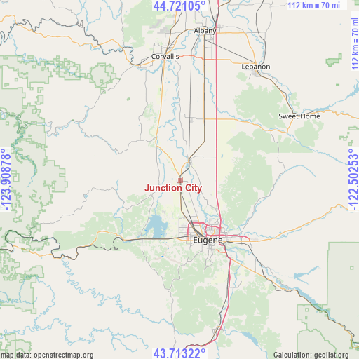
Junction City GPS coordinates[2]
44° 13' 9.444" North, 123° 12' 20.34" West
| Map corner | latitude | longitude |
|---|---|---|
| Upper-left | 44.72105°, | -123.90878° |
| Center: | 44.21929°, | -123.20565° |
| Lower-right: | 43.71322°, | -122.50253° |
| Map W x H: | 112.1×112.1 km | = 69.7×69.7mi |
| max Lat: | 71.29058° ⇑10.7% North |
| Junction City: | 44.21929° |
| min Lat: | ⇓89.3% South 19.06759° |
| min Long | Junction City | max Long |
| -171.73463° | -123.20565° | -66.98998° |
| W 1.9%⇐ | ⇒98.1% E |
Elevation
Elevation of Junction City is 101 m = 331 ft, and this is 193.8 m = 636 ft below average elevation for this country.
| Max E: |
3189 m = 10463 ft | 70% |
| Avg. | 294.8 m = 967 ft | |
| Junction City | 101 m = 331 ft | |
Min E: |
-60 m = -197 ft | 30% |
See also: United States elevation on elevation.city.
Geographical zone
Junction City is located in North temperate zone (between Tropic of Cancer and the Arctic Circle). Distance of this Northern Tropic circle is 2310.8 km =1435.9 mi to South.| Distance of | km | miles | from Junction City |
|---|---|---|---|
| North Pole | 5090.3 | 3163 | to North |
| Arctic Circle | 2484.4 | 1543.7 | to North |
| Tropic Cancer | 2310.8 | 1435.9 | to South |
| Equator | 4916.7 | 3055.1 | to South |


Nearby cities:
15 places around Junction City: (largest is in red/bold)
• Brownsville
26.1 km =16.2 mi,  42°
42°
• Coburg
14.4 km =8.9 mi,  129°
129°
• Corvallis
38.7 km =24 mi,  353°
353°
• Creswell
36.5 km =22.7 mi,  156°
156°
• Eugene
20.9 km =13 mi,  152°
152°
• Halsey
19.8 km =12.3 mi,  22°
22°
• Harrisburg
6.7 km =4.2 mi, 24°
• Lebanon
42.5 km =26.4 mi,  33°
33°
• Monroe
12.8 km =8 mi,  325°
325°
• Philomath
37.9 km =23.5 mi,  340°
340°
• South Lebanon
40 km =24.9 mi, 37°
• Springfield
24.2 km =15 mi,  142°
142°
• Sweet Home
42.3 km =26.3 mi,  62°
62°
• Tangent
36.6 km =22.7 mi,  12°
12°
• Veneta
22.2 km =13.8 mi,  211°
211°
Sources, notices
• [Note1] Compared only with cities in United States existing in our database
• [Src1] Map data: © OpenStreetMap contributors (CC-BY-SA)
• [Src2] Other city data from geonames.org with taken over terms of usage.
• [Src3] Geographical zone / Annual Mean Temperature by Robert A. Rohde @ Wikipedia
