Eugene geodata
Eugene (Oregon) is a seat of a second-order administrative division; located in United States in America/Los_Angeles (GMT-7) time zone. With population of 163,460 people, there are 173 cities with bigger population in this country. Compared to other cities in United States, 88.6% of cities are located further ↓South; 97.9% of cities are located further →East and 64.2% of cities have higher elevation than Eugene. Note1


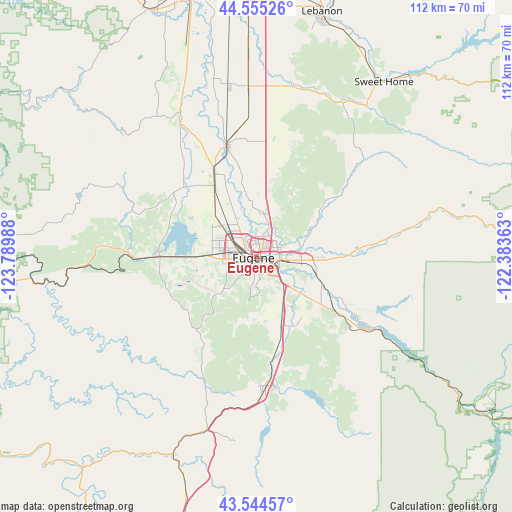
Eugene GPS coordinates[2]
44° 3' 7.452" North, 123° 5' 12.3" West
| Map corner | latitude | longitude |
|---|---|---|
| Upper-left | 44.55526°, | -123.78988° |
| Center: | 44.05207°, | -123.08675° |
| Lower-right: | 43.54457°, | -122.38363° |
| Map W x H: | 112.4×112.4 km | = 69.8×69.8mi |
| max Lat: | 71.29058° ⇑11.4% North |
| Eugene: | 44.05207° |
| min Lat: | ⇓88.6% South 19.06759° |
| min Long | Eugene | max Long |
| -171.73463° | -123.08675° | -66.98998° |
| W 2.1%⇐ | ⇒97.9% E |
Elevation
Elevation of Eugene is 132 m = 433 ft, and this is 162.8 m = 534 ft below average elevation for this country.
| Max E: |
3189 m = 10463 ft | 64.2% |
| Avg. | 294.8 m = 967 ft | |
| Eugene | 132 m = 433 ft | |
Min E: |
-60 m = -197 ft | 35.8% |
See also: Eugene elevation on elevation.city.
Geographical zone
Eugene is located in North temperate zone (between Tropic of Cancer and the Arctic Circle). Distance of this Northern Tropic circle is 2292.2 km =1424.3 mi to South.| Distance of | km | miles | from Eugene |
|---|---|---|---|
| North Pole | 5108.9 | 3174.5 | to North |
| Arctic Circle | 2503 | 1555.3 | to North |
| Tropic Cancer | 2292.2 | 1424.3 | to South |
| Equator | 4898.1 | 3043.5 | to South |


Nearby cities:
15 places around Eugene: (largest is in red/bold)
• Brownsville
38.8 km =24.1 mi,  12°
12°
• Coburg
9.6 km =6 mi, 9°
• Cottage Grove
28.4 km =17.6 mi,  175°
175°
• Creswell
15.7 km =9.8 mi,  161°
161°
• Culp Creek
43.2 km =26.8 mi,  153°
153°
• Drain
47.5 km =29.5 mi,  203°
203°
• Halsey
37 km =23 mi,  357°
357°
• Harrisburg
25.6 km =15.9 mi,  344°
344°
• Junction City
20.9 km =13 mi,  332°
332°
• Lowell
28.4 km =17.6 mi,  121°
121°
• Monroe
33.6 km =20.9 mi, 330°
• South Lebanon
52.6 km =32.7 mi,  16°
16°
• Springfield
5.2 km =3.2 mi,  97°
97°
• Sweet Home
47.5 km =29.5 mi,  36°
36°
• Veneta
21.1 km =13.1 mi,  268°
268°
Sources, notices
• [Note1] Compared only with cities in United States existing in our database
• [Src1] Map data: © OpenStreetMap contributors (CC-BY-SA)
• [Src2] Other city data from geonames.org with taken over terms of usage.
• [Src3] Geographical zone / Annual Mean Temperature by Robert A. Rohde @ Wikipedia
