Tangent geodata
Tangent (Oregon) is a populated place; located in United States in America/Los_Angeles (GMT-7) time zone. With population of 1,220 people, there are 15018 cities with bigger population in this country. Compared to other cities in United States, 90.6% of cities are located further ↓South; 98% of cities are located further →East and 74.4% of cities have higher elevation than Tangent. Note1


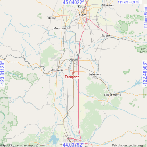
Tangent GPS coordinates[2]
44° 32' 28.428" North, 123° 6' 29.34" West
| Map corner | latitude | longitude |
|---|---|---|
| Upper-left | 45.04022°, | -123.81128° |
| Center: | 44.54123°, | -123.10815° |
| Lower-right: | 44.03792°, | -122.40503° |
| Map W x H: | 111.4×111.4 km | = 69.2×69.2mi |
| max Lat: | 71.29058° ⇑9.4% North |
| Tangent: | 44.54123° |
| min Lat: | ⇓90.6% South 19.06759° |
| min Long | Tangent | max Long |
| -171.73463° | -123.10815° | -66.98998° |
| W 2%⇐ | ⇒98% E |
Elevation
Elevation of Tangent is 75 m = 246 ft, and this is 219.8 m = 721 ft below average elevation for this country.
| Max E: |
3189 m = 10463 ft | 74.4% |
| Avg. | 294.8 m = 967 ft | |
| Tangent | 75 m = 246 ft | |
Min E: |
-60 m = -197 ft | 25.6% |
See also: United States elevation on elevation.city.
Geographical zone
Tangent is located in North temperate zone (between Tropic of Cancer and the Arctic Circle). Distance of this Northern Tropic circle is 2346.6 km =1458.1 mi to South.| Distance of | km | miles | from Tangent |
|---|---|---|---|
| North Pole | 5054.5 | 3140.7 | to North |
| Arctic Circle | 2448.7 | 1521.6 | to North |
| Tropic Cancer | 2346.6 | 1458.1 | to South |
| Equator | 4952.5 | 3077.3 | to South |


Nearby cities:
15 places around Tangent: (largest is in red/bold)
• Adair Village
16.8 km =10.4 mi,  328°
328°
• Albany
10.6 km =6.6 mi,  0°
0°
• Brownsville
19.1 km =11.9 mi,  149°
149°
• Corvallis
12.5 km =7.8 mi,  282°
282°
• Halsey
17.5 km =10.9 mi,  180°
180°
• Harrisburg
30.1 km =18.7 mi,  189°
189°
• Jefferson
21.3 km =13.2 mi,  21°
21°
• Lacomb
29.3 km =18.2 mi,  80°
80°
• Lebanon
15.9 km =9.9 mi,  91°
91°
• Millersburg
16 km =9.9 mi,  13°
13°
• Monroe
29.4 km =18.3 mi,  210°
210°
• Philomath
20.6 km =12.8 mi,  269°
269°
• Scio
27.4 km =17 mi,  48°
48°
• South Lebanon
16.7 km =10.4 mi,  103°
103°
• Sweet Home
33.6 km =20.9 mi,  118°
118°
Sources, notices
• [Note1] Compared only with cities in United States existing in our database
• [Src1] Map data: © OpenStreetMap contributors (CC-BY-SA)
• [Src2] Other city data from geonames.org with taken over terms of usage.
• [Src3] Geographical zone / Annual Mean Temperature by Robert A. Rohde @ Wikipedia
