Harrisburg geodata
Harrisburg (Oregon) is a populated place; located in United States in America/Los_Angeles (GMT-7) time zone. With population of 3,704 people, there are 8585 cities with bigger population in this country. Compared to other cities in United States, 89.5% of cities are located further ↓South; 98% of cities are located further →East and 70.9% of cities have higher elevation than Harrisburg. Note1


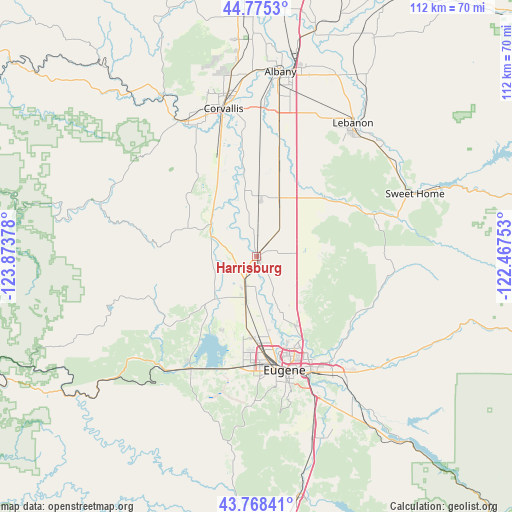
Harrisburg GPS coordinates[2]
44° 16' 26.436" North, 123° 10' 14.34" West
| Map corner | latitude | longitude |
|---|---|---|
| Upper-left | 44.7753°, | -123.87378° |
| Center: | 44.27401°, | -123.17065° |
| Lower-right: | 43.76841°, | -122.46753° |
| Map W x H: | 112×112 km | = 69.6×69.6mi |
| max Lat: | 71.29058° ⇑10.5% North |
| Harrisburg: | 44.27401° |
| min Lat: | ⇓89.5% South 19.06759° |
| min Long | Harrisburg | max Long |
| -171.73463° | -123.17065° | -66.98998° |
| W 2%⇐ | ⇒98% E |
Elevation
Elevation of Harrisburg is 95 m = 312 ft, and this is 199.8 m = 656 ft below average elevation for this country.
| Max E: |
3189 m = 10463 ft | 70.9% |
| Avg. | 294.8 m = 967 ft | |
| Harrisburg | 95 m = 312 ft | |
Min E: |
-60 m = -197 ft | 29.1% |
See also: United States elevation on elevation.city.
Geographical zone
Harrisburg is located in North temperate zone (between Tropic of Cancer and the Arctic Circle). Distance of this Northern Tropic circle is 2316.9 km =1439.7 mi to South.| Distance of | km | miles | from Harrisburg |
|---|---|---|---|
| North Pole | 5084.3 | 3159.2 | to North |
| Arctic Circle | 2478.4 | 1540 | to North |
| Tropic Cancer | 2316.9 | 1439.7 | to South |
| Equator | 4922.8 | 3058.9 | to South |


Nearby cities:
15 places around Harrisburg: (largest is in red/bold)
• Albany
40.6 km =25.2 mi,  7°
7°
• Brownsville
19.9 km =12.4 mi,  48°
48°
• Coburg
17.3 km =10.7 mi,  151°
151°
• Corvallis
33.1 km =20.6 mi,  347°
347°
• Eugene
25.6 km =15.9 mi,  164°
164°
• Halsey
13.2 km =8.2 mi,  21°
21°
• Junction City
6.7 km =4.2 mi,  204°
204°
• Lebanon
35.9 km =22.3 mi,  35°
35°
• Monroe
11 km =6.8 mi,  293°
293°
• Philomath
33.5 km =20.8 mi,  332°
332°
• South Lebanon
33.4 km =20.8 mi, 39°
• Springfield
28 km =17.4 mi, 154°
• Sweet Home
37.2 km =23.1 mi,  68°
68°
• Tangent
30.1 km =18.7 mi, 9°
• Veneta
28.9 km =18 mi,  209°
209°
Sources, notices
• [Note1] Compared only with cities in United States existing in our database
• [Src1] Map data: © OpenStreetMap contributors (CC-BY-SA)
• [Src2] Other city data from geonames.org with taken over terms of usage.
• [Src3] Geographical zone / Annual Mean Temperature by Robert A. Rohde @ Wikipedia
