Garrett geodata
Garrett (Washington) is a populated place; located in United States in America/Los_Angeles (GMT-7) time zone. With population of 1,419 people, there are 14021 cities with bigger population in this country. Compared to other cities in United States, 95.1% of cities are located further ↓South; 91.5% of cities are located further →East and 58.6% of cities have lower elevation than Garrett. Note1


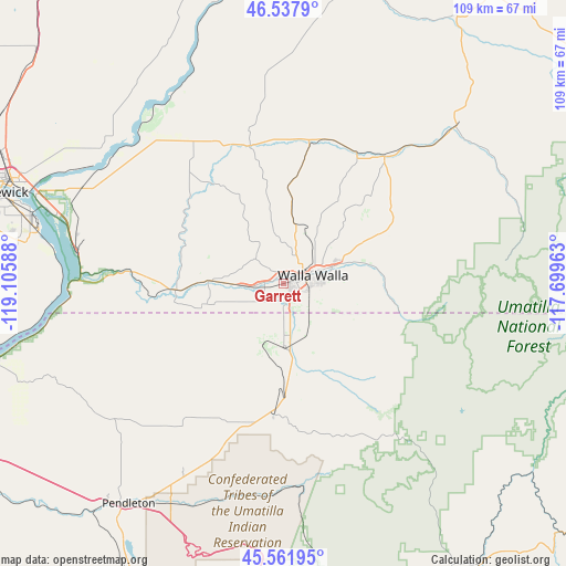
Garrett GPS coordinates[2]
46° 3' 7.488" North, 118° 24' 9.9" West
| Map corner | latitude | longitude |
|---|---|---|
| Upper-left | 46.5379°, | -119.10588° |
| Center: | 46.05208°, | -118.40275° |
| Lower-right: | 45.56195°, | -117.69963° |
| Map W x H: | 108.5×108.5 km | = 67.4×67.4mi |
| max Lat: | 71.29058° ⇑4.9% North |
| Garrett: | 46.05208° |
| min Lat: | ⇓95.1% South 19.06759° |
| min Long | Garrett | max Long |
| -171.73463° | -118.40275° | -66.98998° |
| W 8.5%⇐ | ⇒91.5% E |
Elevation
Elevation of Garrett is 233 m = 764 ft, and this is 61.8 m = 203 ft below average elevation for this country.
| Max E: |
3189 m = 10463 ft | 41.4% |
| Avg. | 294.8 m = 967 ft | |
| Garrett | 233 m = 764 ft | |
Min E: |
-60 m = -197 ft | 58.6% |
See also: United States elevation on elevation.city.
Geographical zone
Garrett is located in North temperate zone (between Tropic of Cancer and the Arctic Circle). Distance of this North polar circle is 2280.7 km =1417.2 mi to North.| Distance of | km | miles | from Garrett |
|---|---|---|---|
| North Pole | 4886.6 | 3036.4 | to North |
| Arctic Circle | 2280.7 | 1417.2 | to North |
| Tropic Cancer | 2514.6 | 1562.5 | to South |
| Equator | 5120.5 | 3181.7 | to South |


Nearby cities:
15 places around Garrett: (largest is in red/bold)
• Athena
27.6 km =17.1 mi,  194°
194°
• Burbank
49.8 km =30.9 mi,  289°
289°
• College Place
1.2 km =0.7 mi,  105°
105°
• Dayton
44.8 km =27.8 mi,  47°
47°
• Finley
50 km =31.1 mi,  283°
283°
• Highland
55.6 km =34.5 mi, 279°
• Kennewick
59.3 km =36.8 mi, 287°
• Milton-Freewater
13.3 km =8.3 mi,  175°
175°
• Mission
47.7 km =29.6 mi,  207°
207°
• Pasco
57.7 km =35.9 mi, 291°
• Pendleton
51.7 km =32.1 mi,  215°
215°
• Waitsburg
31 km =19.3 mi,  38°
38°
• Walla Walla
4.8 km =3 mi,  73°
73°
• Walla Walla East
7.6 km =4.7 mi,  90°
90°
• Weston
26.6 km =16.5 mi, 183°
Sources, notices
• [Note1] Compared only with cities in United States existing in our database
• [Src1] Map data: © OpenStreetMap contributors (CC-BY-SA)
• [Src2] Other city data from geonames.org with taken over terms of usage.
• [Src3] Geographical zone / Annual Mean Temperature by Robert A. Rohde @ Wikipedia
