Magna geodata
Magna (Utah) is a populated place; located in United States in America/Denver (GMT-6) time zone. With population of 26,505 people, there are 1888 cities with bigger population in this country. Compared to other cities in United States, 61.7% of cities are located further ↓South; 87.7% of cities are located further →East and 95.3% of cities have lower elevation than Magna. Note1


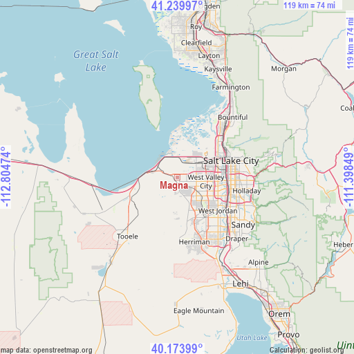
Magna GPS coordinates[2]
40° 42' 32.796" North, 112° 6' 5.796" West
| Map corner | latitude | longitude |
|---|---|---|
| Upper-left | 41.23997°, | -112.80474° |
| Center: | 40.70911°, | -112.10161° |
| Lower-right: | 40.17399°, | -111.39849° |
| Map W x H: | 118.5×118.5 km | = 73.6×73.6mi |
| max Lat: | 71.29058° ⇑38.3% North |
| Magna: | 40.70911° |
| min Lat: | ⇓61.7% South 19.06759° |
| min Long | Magna | max Long |
| -171.73463° | -112.10161° | -66.98998° |
| W 12.3%⇐ | ⇒87.7% E |
Elevation
Elevation of Magna is 1312 m = 4304 ft, and this is 1017.2 m = 3337 ft above average elevation for this country.
| Max E: |
3189 m = 10463 ft | 4.7% |
| Magna | 1312 m 4304 ft | |
| Avg. | 294.8 m = 967 ft | |
Min E: |
-60 m = -197 ft | 95.3% |
See also: United States elevation on elevation.city.
Geographical zone
Magna is located in North temperate zone (between Tropic of Cancer and the Arctic Circle). Distance of this Northern Tropic circle is 1920.5 km =1193.3 mi to South.| Distance of | km | miles | from Magna |
|---|---|---|---|
| North Pole | 5480.6 | 3405.5 | to North |
| Arctic Circle | 2874.7 | 1786.3 | to North |
| Tropic Cancer | 1920.5 | 1193.3 | to South |
| Equator | 4526.4 | 2812.6 | to South |


Nearby cities:
15 places around Magna: (largest is in red/bold)
• Bingham Canyon
16.9 km =10.5 mi,  188°
188°
• Centerfield
17.3 km =10.7 mi,  96°
96°
• Copperton
16.1 km =10 mi,  178°
178°
• Erda
20.2 km =12.6 mi,  237°
237°
• Kearns
10.4 km =6.5 mi,  121°
121°
• Midvale
20.2 km =12.6 mi, 122°
• Millcreek
19.2 km =11.9 mi, 97°
• Murray
18.6 km =11.6 mi, 104°
• Oquirrh
10.4 km =6.5 mi,  146°
146°
• Salt Lake City
18.6 km =11.6 mi,  72°
72°
• South Salt Lake
18 km =11.2 mi,  86°
86°
• Stansbury park
18.2 km =11.3 mi, 244°
• Taylorsville
14.5 km =9 mi,  108°
108°
• West Jordan
17.6 km =10.9 mi,  128°
128°
• West Valley City
8.7 km =5.4 mi, 102°
Sources, notices
• [Note1] Compared only with cities in United States existing in our database
• [Src1] Map data: © OpenStreetMap contributors (CC-BY-SA)
• [Src2] Other city data from geonames.org with taken over terms of usage.
• [Src3] Geographical zone / Annual Mean Temperature by Robert A. Rohde @ Wikipedia
