Stansbury park geodata
Stansbury park (Utah) is a populated place; located in United States in America/Denver (GMT-6) time zone. With population of 5,145 people, there are 7047 cities with bigger population in this country. Compared to other cities in United States, 60.6% of cities are located further ↓South; 87.9% of cities are located further →East and 95.3% of cities have lower elevation than Stansbury park. Note1


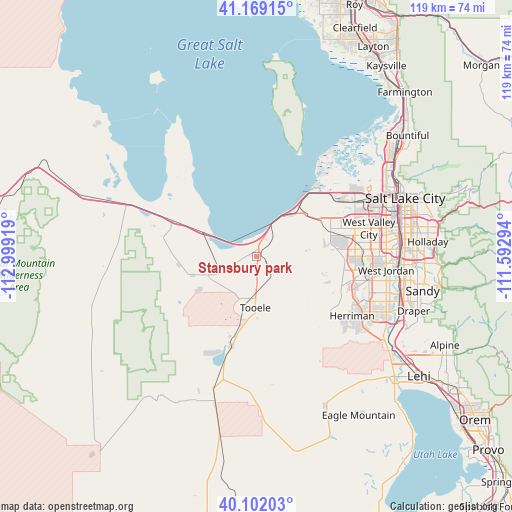
Stansbury park GPS coordinates[2]
40° 38' 15.792" North, 112° 17' 45.816" West
| Map corner | latitude | longitude |
|---|---|---|
| Upper-left | 41.16915°, | -112.99919° |
| Center: | 40.63772°, | -112.29606° |
| Lower-right: | 40.10203°, | -111.59294° |
| Map W x H: | 118.7×118.7 km | = 73.8×73.8mi |
| max Lat: | 71.29058° ⇑39.4% North |
| Stansbury park: | 40.63772° |
| min Lat: | ⇓60.6% South 19.06759° |
| min Long | Stansbury park | max Long |
| -171.73463° | -112.29606° | -66.98998° |
| W 12.1%⇐ | ⇒87.9% E |
Elevation
Elevation of Stansbury park is 1310 m = 4298 ft, and this is 1015.2 m = 3331 ft above average elevation for this country.
| Max E: |
3189 m = 10463 ft | 4.7% |
| Stansbury park | 1310 m 4298 ft | |
| Avg. | 294.8 m = 967 ft | |
Min E: |
-60 m = -197 ft | 95.3% |
See also: United States elevation on elevation.city.
Geographical zone
Stansbury park is located in North temperate zone (between Tropic of Cancer and the Arctic Circle). Distance of this Northern Tropic circle is 1912.6 km =1188.4 mi to South.| Distance of | km | miles | from Stansbury park |
|---|---|---|---|
| North Pole | 5488.6 | 3410.5 | to North |
| Arctic Circle | 2882.7 | 1791.2 | to North |
| Tropic Cancer | 1912.6 | 1188.4 | to South |
| Equator | 4518.5 | 2807.7 | to South |


Nearby cities:
15 places around Stansbury park: (largest is in red/bold)
• Bingham Canyon
16.5 km =10.3 mi,  122°
122°
• Copperton
18.6 km =11.6 mi, 115°
• Erda
2.9 km =1.8 mi,  194°
194°
• Grantsville
14.8 km =9.2 mi,  253°
253°
• Herriman
26.1 km =16.2 mi, 121°
• Kearns
25.4 km =15.8 mi,  84°
84°
• Magna
18.2 km =11.3 mi,  64°
64°
• Oquirrh
22.1 km =13.7 mi,  92°
92°
• South Jordan
32.1 km =19.9 mi,  105°
105°
• South Jordan Heights
30.4 km =18.9 mi, 105°
• Stockton
21.3 km =13.2 mi, 194°
• Taylorsville
30.3 km =18.8 mi, 83°
• Tooele
11.9 km =7.4 mi,  180°
180°
• West Jordan
30.3 km =18.8 mi,  95°
95°
• West Valley City
25.6 km =15.9 mi, 76°
Sources, notices
• [Note1] Compared only with cities in United States existing in our database
• [Src1] Map data: © OpenStreetMap contributors (CC-BY-SA)
• [Src2] Other city data from geonames.org with taken over terms of usage.
• [Src3] Geographical zone / Annual Mean Temperature by Robert A. Rohde @ Wikipedia
