Murray geodata
Murray (Utah) is a populated place; located in United States in America/Denver (GMT-6) time zone. With population of 49,250 people, there are 971 cities with bigger population in this country. Compared to other cities in United States, 61.1% of cities are located further ↓South; 87.2% of cities are located further →East and 95.3% of cities have lower elevation than Murray. Note1


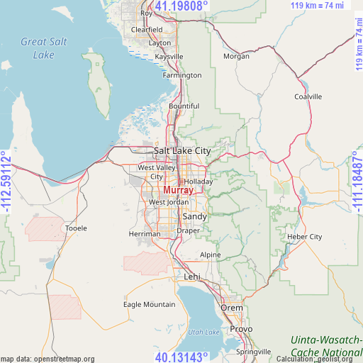
Murray GPS coordinates[2]
40° 40' 0.804" North, 111° 53' 16.764" West
| Map corner | latitude | longitude |
|---|---|---|
| Upper-left | 41.19808°, | -112.59112° |
| Center: | 40.66689°, | -111.88799° |
| Lower-right: | 40.13143°, | -111.18487° |
| Map W x H: | 118.6×118.6 km | = 73.7×73.7mi |
| max Lat: | 71.29058° ⇑38.9% North |
| Murray: | 40.66689° |
| min Lat: | ⇓61.1% South 19.06759° |
| min Long | Murray | max Long |
| -171.73463° | -111.88799° | -66.98998° |
| W 12.8%⇐ | ⇒87.2% E |
Elevation
Elevation of Murray is 1317 m = 4321 ft, and this is 1022.2 m = 3354 ft above average elevation for this country.
| Max E: |
3189 m = 10463 ft | 4.7% |
| Murray | 1317 m 4321 ft | |
| Avg. | 294.8 m = 967 ft | |
Min E: |
-60 m = -197 ft | 95.3% |
See also: Murray elevation on elevation.city.
Geographical zone
Murray is located in North temperate zone (between Tropic of Cancer and the Arctic Circle). Distance of this Northern Tropic circle is 1915.8 km =1190.4 mi to South.| Distance of | km | miles | from Murray |
|---|---|---|---|
| North Pole | 5485.3 | 3408.4 | to North |
| Arctic Circle | 2879.4 | 1789.2 | to North |
| Tropic Cancer | 1915.8 | 1190.4 | to South |
| Equator | 4521.7 | 2809.7 | to South |


Nearby cities:
15 places around Murray: (largest is in red/bold)
• Canyon Rim
7.1 km =4.4 mi,  51°
51°
• Centerfield
2.8 km =1.7 mi,  342°
342°
• Cottonwood Heights
8.4 km =5.2 mi,  128°
128°
• East Millcreek
7.5 km =4.7 mi,  60°
60°
• Holladay
5.3 km =3.3 mi,  87°
87°
• Kearns
9.2 km =5.7 mi,  265°
265°
• Little Cottonwood Creek Valley
8.5 km =5.3 mi,  144°
144°
• Midvale
6.3 km =3.9 mi,  189°
189°
• Millcreek
2.5 km =1.6 mi,  25°
25°
• Mount Olympus
8.6 km =5.3 mi,  76°
76°
• Sandy
8.4 km =5.2 mi,  177°
177°
• South Salt Lake
5.8 km =3.6 mi,  359°
359°
• Taylorsville
4.3 km =2.7 mi, 271°
• West Jordan
7.7 km =4.8 mi,  214°
214°
• Willard
6.1 km =3.8 mi,  44°
44°
Sources, notices
• [Note1] Compared only with cities in United States existing in our database
• [Src1] Map data: © OpenStreetMap contributors (CC-BY-SA)
• [Src2] Other city data from geonames.org with taken over terms of usage.
• [Src3] Geographical zone / Annual Mean Temperature by Robert A. Rohde @ Wikipedia
