Oquirrh geodata
Oquirrh (Utah) is a populated place; located in United States in America/Denver (GMT-6) time zone. With population of 11,668 people, there are 3976 cities with bigger population in this country. Compared to other cities in United States, 60.5% of cities are located further ↓South; 87.6% of cities are located further →East and 96.7% of cities have lower elevation than Oquirrh. Note1


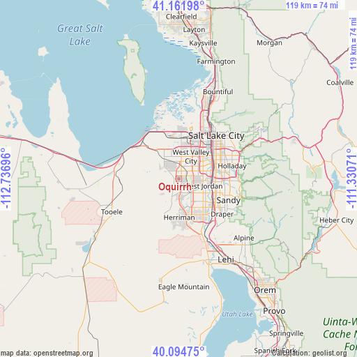
Oquirrh GPS coordinates[2]
40° 37' 49.8" North, 112° 2' 1.788" West
| Map corner | latitude | longitude |
|---|---|---|
| Upper-left | 41.16198°, | -112.73696° |
| Center: | 40.6305°, | -112.03383° |
| Lower-right: | 40.09475°, | -111.33071° |
| Map W x H: | 118.7×118.7 km | = 73.8×73.8mi |
| max Lat: | 71.29058° ⇑39.5% North |
| Oquirrh: | 40.6305° |
| min Lat: | ⇓60.5% South 19.06759° |
| min Long | Oquirrh | max Long |
| -171.73463° | -112.03383° | -66.98998° |
| W 12.4%⇐ | ⇒87.6% E |
Elevation
Elevation of Oquirrh is 1504 m = 4934 ft, and this is 1209.2 m = 3967 ft above average elevation for this country.
| Max E: |
3189 m = 10463 ft | 3.3% |
| Oquirrh | 1504 m 4934 ft | |
| Avg. | 294.8 m = 967 ft | |
Min E: |
-60 m = -197 ft | 96.7% |
See also: United States elevation on elevation.city.
Geographical zone
Oquirrh is located in North temperate zone (between Tropic of Cancer and the Arctic Circle). Distance of this Northern Tropic circle is 1911.8 km =1187.9 mi to South.| Distance of | km | miles | from Oquirrh |
|---|---|---|---|
| North Pole | 5489.4 | 3411 | to North |
| Arctic Circle | 2883.5 | 1791.7 | to North |
| Tropic Cancer | 1911.8 | 1187.9 | to South |
| Equator | 4517.7 | 2807.2 | to South |


Nearby cities:
15 places around Oquirrh: (largest is in red/bold)
• Bingham Canyon
11.4 km =7.1 mi,  225°
225°
• Centerfield
13.3 km =8.3 mi,  59°
59°
• Copperton
9.1 km =5.7 mi,  216°
216°
• Herriman
12.9 km =8 mi,  179°
179°
• Kearns
4.6 km =2.9 mi,  44°
44°
• Magna
10.4 km =6.5 mi,  326°
326°
• Midvale
11.5 km =7.1 mi,  100°
100°
• Murray
13 km =8.1 mi,  71°
71°
• Riverton
14.5 km =9 mi,  146°
146°
• Sandy
13.4 km =8.3 mi,  108°
108°
• South Jordan
11.6 km =7.2 mi,  130°
130°
• South Jordan Heights
10.3 km =6.4 mi,  136°
136°
• Taylorsville
9 km =5.6 mi, 62°
• West Jordan
8.3 km =5.2 mi, 106°
• West Valley City
7.3 km =4.5 mi,  22°
22°
Sources, notices
• [Note1] Compared only with cities in United States existing in our database
• [Src1] Map data: © OpenStreetMap contributors (CC-BY-SA)
• [Src2] Other city data from geonames.org with taken over terms of usage.
• [Src3] Geographical zone / Annual Mean Temperature by Robert A. Rohde @ Wikipedia
