Mount Olympus geodata
Mount Olympus (Utah) is a populated place; located in United States in America/Denver (GMT-6) time zone. With population of 6,748 people, there are 5955 cities with bigger population in this country. Compared to other cities in United States, 61.4% of cities are located further ↓South; 86.9% of cities are located further →East and 97.2% of cities have lower elevation than Mount Olympus. Note1


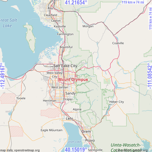
Mount Olympus GPS coordinates[2]
40° 41' 7.8" North, 111° 47' 18.744" West
| Map corner | latitude | longitude |
|---|---|---|
| Upper-left | 41.21654°, | -112.49167° |
| Center: | 40.6855°, | -111.78854° |
| Lower-right: | 40.15019°, | -111.08542° |
| Map W x H: | 118.6×118.6 km | = 73.7×73.7mi |
| max Lat: | 71.29058° ⇑38.6% North |
| Mount Olympus: | 40.6855° |
| min Lat: | ⇓61.4% South 19.06759° |
| min Long | Mount Olympus | max Long |
| -171.73463° | -111.78854° | -66.98998° |
| W 13.1%⇐ | ⇒86.9% E |
Elevation
Elevation of Mount Olympus is 1565 m = 5135 ft, and this is 1270.2 m = 4167 ft above average elevation for this country.
| Max E: |
3189 m = 10463 ft | 2.8% |
| Mount Olympus | 1565 m 5135 ft | |
| Avg. | 294.8 m = 967 ft | |
Min E: |
-60 m = -197 ft | 97.2% |
See also: United States elevation on elevation.city.
Geographical zone
Mount Olympus is located in North temperate zone (between Tropic of Cancer and the Arctic Circle). Distance of this Northern Tropic circle is 1917.9 km =1191.7 mi to South.| Distance of | km | miles | from Mount Olympus |
|---|---|---|---|
| North Pole | 5483.3 | 3407.2 | to North |
| Arctic Circle | 2877.4 | 1787.9 | to North |
| Tropic Cancer | 1917.9 | 1191.7 | to South |
| Equator | 4523.8 | 2811 | to South |


Nearby cities:
15 places around Mount Olympus: (largest is in red/bold)
• Canyon Rim
3.7 km =2.3 mi,  309°
309°
• Centerfield
9.3 km =5.8 mi,  274°
274°
• Cottonwood Heights
7.5 km =4.7 mi,  194°
194°
• East Millcreek
2.5 km =1.6 mi, 310°
• Granite
12.6 km =7.8 mi, 186°
• Holladay
3.6 km =2.2 mi,  238°
238°
• Little Cottonwood Creek Valley
9.7 km =6 mi,  200°
200°
• Midvale
12.5 km =7.8 mi,  228°
228°
• Millcreek
7.3 km =4.5 mi, 271°
• Murray
8.6 km =5.3 mi,  256°
256°
• Salt Lake City
12 km =7.5 mi, 314°
• Sandy Hills
12.7 km =7.9 mi, 204°
• South Salt Lake
9.2 km =5.7 mi,  293°
293°
• Taylorsville
12.8 km =8 mi, 261°
• Willard
4.7 km =2.9 mi,  299°
299°
Sources, notices
• [Note1] Compared only with cities in United States existing in our database
• [Src1] Map data: © OpenStreetMap contributors (CC-BY-SA)
• [Src2] Other city data from geonames.org with taken over terms of usage.
• [Src3] Geographical zone / Annual Mean Temperature by Robert A. Rohde @ Wikipedia
