Little Cottonwood Creek Valley geodata
Little Cottonwood Creek Valley (Utah) is a populated place; located in United States in America/Denver (GMT-6) time zone. With population of 8,285 people, there are 5144 cities with bigger population in this country. Compared to other cities in United States, 60.1% of cities are located further ↓South; 87% of cities are located further →East and 96.1% of cities have lower elevation than Little Cottonwood Creek Valley. Note1
Current local time in Little Cottonwood Creek Valley:
06:23 AM, FridayDifference from your time zone: hours


Little Cottonwood Creek Valley GPS coordinates[2]
40° 36' 15.804" North, 111° 49' 45.768" West
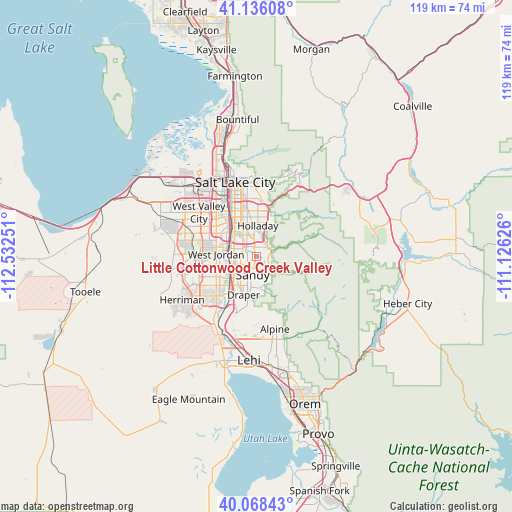
| Map corner | latitude | longitude |
|---|---|---|
| Upper-left | 41.13608°, | -112.53251° |
| Center: | 40.60439°, | -111.82938° |
| Lower-right: | 40.06843°, | -111.12626° |
| Map W x H: | 118.7×118.7 km | = 73.8×73.8mi |
| max Lat: | 71.29058° ⇑39.9% North |
| Little Cottonwood Creek Valley: | 40.60439° |
| min Lat: | ⇓60.1% South 19.06759° |
| min Long | Little Cottonwo | max Long |
| -171.73463° | -111.82938° | -66.98998° |
| W 13%⇐ | ⇒87% E |
Elevation
Elevation of Little Cottonwood Creek Valley is 1415 m = 4642 ft, and this is 1120.2 m = 3675 ft above average elevation for this country.
| Max E: |
3189 m = 10463 ft | 3.9% |
| Little Cottonwood Creek Valley | 1415 m 4642 ft | |
| Avg. | 294.8 m = 967 ft | |
Min E: |
-60 m = -197 ft | 96.1% |
See also: United States elevation on elevation.city.
Geographical zone
Little Cottonwood Creek Valley is located in North temperate zone (between Tropic of Cancer and the Arctic Circle). Distance of this Northern Tropic circle is 1908.9 km =1186.1 mi to South.| Distance of | km | miles | from Little Cottonwood Creek Valley |
|---|---|---|---|
| North Pole | 5492.3 | 3412.8 | to North |
| Arctic Circle | 2886.4 | 1793.5 | to North |
| Tropic Cancer | 1908.9 | 1186.1 | to South |
| Equator | 4514.8 | 2805.4 | to South |


Nearby cities:
15 places around Little Cottonwood Creek Valley: (largest is in red/bold)
• Cottonwood Heights
2.3 km =1.4 mi,  43°
43°
• Draper
9.3 km =5.8 mi,  198°
198°
• East Millcreek
10.7 km =6.6 mi,  8°
8°
• Granite
4 km =2.5 mi,  150°
150°
• Holladay
7.2 km =4.5 mi,  3°
3°
• Midvale
6 km =3.7 mi,  277°
277°
• Millcreek
10 km =6.2 mi,  337°
337°
• Mount Olympus
9.7 km =6 mi,  20°
20°
• Murray
8.5 km =5.3 mi,  324°
324°
• Sandy
4.8 km =3 mi,  252°
252°
• Sandy Hills
3.2 km =2 mi,  214°
214°
• South Jordan
9.7 km =6 mi,  240°
240°
• South Jordan Heights
11.1 km =6.9 mi, 246°
• West Jordan
9.3 km =5.8 mi,  273°
273°
• White City
5.2 km =3.2 mi, 214°
Sources, notices
• [Note1] Compared only with cities in United States existing in our database
• [Src1] Map data: © OpenStreetMap contributors (CC-BY-SA)
• [Src2] Other city data from geonames.org with taken over terms of usage.
• [Src3] Geographical zone / Annual Mean Temperature by Robert A. Rohde @ Wikipedia
