Cottonwood Heights geodata
Cottonwood Heights (Utah) is a populated place; located in United States in America/Denver (GMT-6) time zone. With population of 34,343 people, there are 1433 cities with bigger population in this country. Compared to other cities in United States, 60.3% of cities are located further ↓South; 87% of cities are located further →East and 96.5% of cities have lower elevation than Cottonwood Heights. Note1


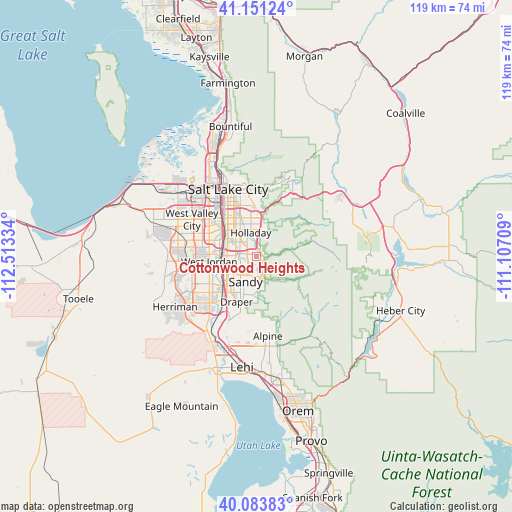
Cottonwood Heights GPS coordinates[2]
40° 37' 10.812" North, 111° 48' 36.756" West
| Map corner | latitude | longitude |
|---|---|---|
| Upper-left | 41.15124°, | -112.51334° |
| Center: | 40.61967°, | -111.81021° |
| Lower-right: | 40.08383°, | -111.10709° |
| Map W x H: | 118.7×118.7 km | = 73.8×73.8mi |
| max Lat: | 71.29058° ⇑39.7% North |
| Cottonwood Heights: | 40.61967° |
| min Lat: | ⇓60.3% South 19.06759° |
| min Long | Cottonwood Heig | max Long |
| -171.73463° | -111.81021° | -66.98998° |
| W 13%⇐ | ⇒87% E |
Elevation
Elevation of Cottonwood Heights is 1473 m = 4833 ft, and this is 1178.2 m = 3865 ft above average elevation for this country.
| Max E: |
3189 m = 10463 ft | 3.5% |
| Cottonwood Heights | 1473 m 4833 ft | |
| Avg. | 294.8 m = 967 ft | |
Min E: |
-60 m = -197 ft | 96.5% |
See also: United States elevation on elevation.city.
Geographical zone
Cottonwood Heights is located in North temperate zone (between Tropic of Cancer and the Arctic Circle). Distance of this Northern Tropic circle is 1910.6 km =1187.2 mi to South.| Distance of | km | miles | from Cottonwood Heights |
|---|---|---|---|
| North Pole | 5490.6 | 3411.7 | to North |
| Arctic Circle | 2884.7 | 1792.5 | to North |
| Tropic Cancer | 1910.6 | 1187.2 | to South |
| Equator | 4516.5 | 2806.4 | to South |


Nearby cities:
15 places around Cottonwood Heights: (largest is in red/bold)
• Canyon Rim
9.7 km =6 mi,  354°
354°
• Centerfield
10.9 km =6.8 mi,  317°
317°
• East Millcreek
8.9 km =5.5 mi,  359°
359°
• Granite
5.2 km =3.2 mi,  176°
176°
• Holladay
5.6 km =3.5 mi, 347°
• Little Cottonwood Creek Valley
2.3 km =1.4 mi,  223°
223°
• Midvale
7.6 km =4.7 mi,  262°
262°
• Millcreek
9.3 km =5.8 mi, 323°
• Mount Olympus
7.5 km =4.7 mi,  14°
14°
• Murray
8.4 km =5.2 mi,  308°
308°
• Sandy
7 km =4.3 mi,  243°
243°
• Sandy Hills
5.5 km =3.4 mi, 218°
• West Jordan
10.9 km =6.8 mi, 264°
• White City
7.5 km =4.7 mi, 217°
• Willard
9.9 km =6.2 mi, 346°
Sources, notices
• [Note1] Compared only with cities in United States existing in our database
• [Src1] Map data: © OpenStreetMap contributors (CC-BY-SA)
• [Src2] Other city data from geonames.org with taken over terms of usage.
• [Src3] Geographical zone / Annual Mean Temperature by Robert A. Rohde @ Wikipedia
