Sandy geodata
Sandy (Utah) is a populated place; located in United States in America/Denver (GMT-6) time zone. With population of 87,461 people, there are 431 cities with bigger population in this country. Compared to other cities in United States, 59.9% of cities are located further ↓South; 87.2% of cities are located further →East and 95.7% of cities have lower elevation than Sandy. Note1


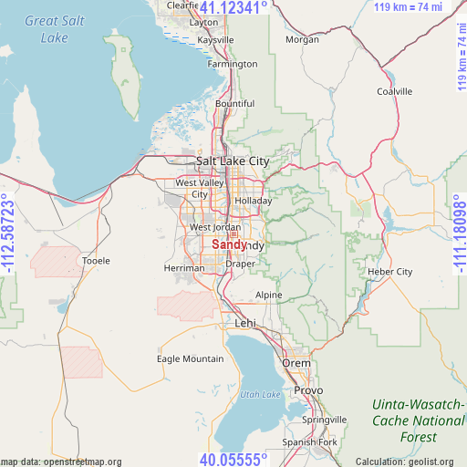
Sandy GPS coordinates[2]
40° 35' 29.796" North, 111° 53' 2.76" West
| Map corner | latitude | longitude |
|---|---|---|
| Upper-left | 41.12341°, | -112.58723° |
| Center: | 40.59161°, | -111.8841° |
| Lower-right: | 40.05555°, | -111.18098° |
| Map W x H: | 118.7×118.7 km | = 73.8×73.8mi |
| max Lat: | 71.29058° ⇑40.1% North |
| Sandy: | 40.59161° |
| min Lat: | ⇓59.9% South 19.06759° |
| min Long | Sandy | max Long |
| -171.73463° | -111.8841° | -66.98998° |
| W 12.8%⇐ | ⇒87.2% E |
Elevation
Elevation of Sandy is 1366 m = 4482 ft, and this is 1071.2 m = 3514 ft above average elevation for this country.
| Max E: |
3189 m = 10463 ft | 4.3% |
| Sandy | 1366 m 4482 ft | |
| Avg. | 294.8 m = 967 ft | |
Min E: |
-60 m = -197 ft | 95.7% |
See also: Sandy elevation on elevation.city.
Geographical zone
Sandy is located in North temperate zone (between Tropic of Cancer and the Arctic Circle). Distance of this Northern Tropic circle is 1907.4 km =1185.2 mi to South.| Distance of | km | miles | from Sandy |
|---|---|---|---|
| North Pole | 5493.7 | 3413.6 | to North |
| Arctic Circle | 2887.8 | 1794.4 | to North |
| Tropic Cancer | 1907.4 | 1185.2 | to South |
| Equator | 4513.4 | 2804.5 | to South |


Nearby cities:
15 places around Sandy: (largest is in red/bold)
• Cottonwood Heights
7 km =4.3 mi,  63°
63°
• Draper
7.6 km =4.7 mi,  167°
167°
• Granite
6.9 km =4.3 mi,  107°
107°
• Holladay
9.9 km =6.2 mi,  30°
30°
• Little Cottonwood Creek Valley
4.8 km =3 mi,  72°
72°
• Midvale
2.5 km =1.6 mi,  328°
328°
• Millcreek
10.6 km =6.6 mi,  3°
3°
• Murray
8.4 km =5.2 mi,  357°
357°
• Riverton
9 km =5.6 mi,  210°
210°
• Sandy Hills
3 km =1.9 mi, 112°
• South Jordan
5.1 km =3.2 mi,  229°
229°
• South Jordan Heights
6.3 km =3.9 mi,  240°
240°
• Taylorsville
9.6 km =6 mi, 331°
• West Jordan
5.1 km =3.2 mi,  293°
293°
• White City
3.3 km =2.1 mi,  149°
149°
Sources, notices
• [Note1] Compared only with cities in United States existing in our database
• [Src1] Map data: © OpenStreetMap contributors (CC-BY-SA)
• [Src2] Other city data from geonames.org with taken over terms of usage.
• [Src3] Geographical zone / Annual Mean Temperature by Robert A. Rohde @ Wikipedia
