Stockton geodata
Stockton (Utah) is a populated place; located in United States in America/Denver (GMT-6) time zone. With population of 642 people, there are 19249 cities with bigger population in this country. Compared to other cities in United States, 58.5% of cities are located further ↓South; 88% of cities are located further →East and 97.1% of cities have lower elevation than Stockton. Note1


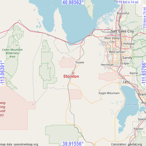
Stockton GPS coordinates[2]
40° 27' 9.792" North, 112° 21' 38.808" West
| Map corner | latitude | longitude |
|---|---|---|
| Upper-left | 40.98562°, | -113.06391° |
| Center: | 40.45272°, | -112.36078° |
| Lower-right: | 39.91556°, | -111.65766° |
| Map W x H: | 119×119 km | = 73.9×73.9mi |
| max Lat: | 71.29058° ⇑41.5% North |
| Stockton: | 40.45272° |
| min Lat: | ⇓58.5% South 19.06759° |
| min Long | Stockton | max Long |
| -171.73463° | -112.36078° | -66.98998° |
| W 12%⇐ | ⇒88% E |
Elevation
Elevation of Stockton is 1560 m = 5118 ft, and this is 1265.2 m = 4151 ft above average elevation for this country.
| Max E: |
3189 m = 10463 ft | 2.9% |
| Stockton | 1560 m 5118 ft | |
| Avg. | 294.8 m = 967 ft | |
Min E: |
-60 m = -197 ft | 97.1% |
See also: United States elevation on elevation.city.
Geographical zone
Stockton is located in North temperate zone (between Tropic of Cancer and the Arctic Circle). Distance of this Northern Tropic circle is 1892 km =1175.6 mi to South.| Distance of | km | miles | from Stockton |
|---|---|---|---|
| North Pole | 5509.1 | 3423.2 | to North |
| Arctic Circle | 2903.3 | 1804 | to North |
| Tropic Cancer | 1892 | 1175.6 | to South |
| Equator | 4497.9 | 2794.9 | to South |


Nearby cities:
15 places around Stockton: (largest is in red/bold)
• Bingham Canyon
22.7 km =14.1 mi,  58°
58°
• Bluffdale
35.9 km =22.3 mi,  83°
83°
• Cedar Valley
27.2 km =16.9 mi,  119°
119°
• Copperton
25.5 km =15.8 mi, 60°
• Eagle Mountain
33.7 km =20.9 mi, 117°
• Erda
18.4 km =11.4 mi,  14°
14°
• Grantsville
18.6 km =11.6 mi,  331°
331°
• Herriman
28.5 km =17.7 mi, 76°
• Magna
35.9 km =22.3 mi,  37°
37°
• Oquirrh
34 km =21.1 mi,  54°
54°
• Riverton
36.5 km =22.7 mi, 77°
• South Jordan
38.4 km =23.9 mi,  71°
71°
• South Jordan Heights
36.9 km =22.9 mi, 70°
• Stansbury park
21.3 km =13.2 mi, 14°
• Tooele
10.2 km =6.3 mi,  31°
31°
Sources, notices
• [Note1] Compared only with cities in United States existing in our database
• [Src1] Map data: © OpenStreetMap contributors (CC-BY-SA)
• [Src2] Other city data from geonames.org with taken over terms of usage.
• [Src3] Geographical zone / Annual Mean Temperature by Robert A. Rohde @ Wikipedia
