Everson geodata
Everson (Washington) is a populated place; located in United States in America/Los_Angeles (GMT-7) time zone. With population of 2,600 people, there are 10394 cities with bigger population in this country. Compared to other cities in United States, 99.4% of cities are located further ↓South; 96.2% of cities are located further →East and 86.2% of cities have higher elevation than Everson. Note1


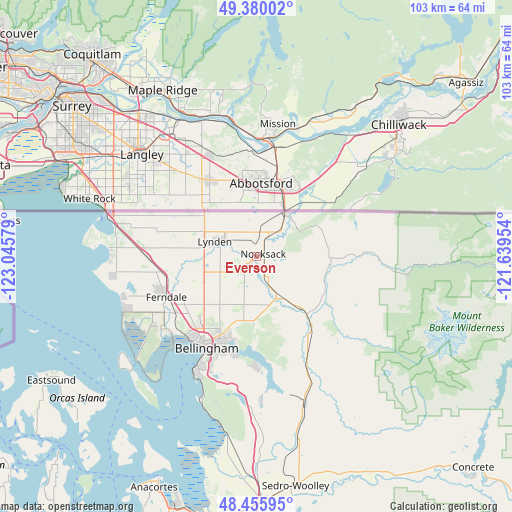
Everson GPS coordinates[2]
48° 55' 12.432" North, 122° 20' 33.576" West
| Map corner | latitude | longitude |
|---|---|---|
| Upper-left | 49.38002°, | -123.04579° |
| Center: | 48.92012°, | -122.34266° |
| Lower-right: | 48.45595°, | -121.63954° |
| Map W x H: | 102.7×102.7 km | = 63.8×63.8mi |
| max Lat: | 71.29058° ⇑0.6% North |
| Everson: | 48.92012° |
| min Lat: | ⇓99.4% South 19.06759° |
| min Long | Everson | max Long |
| -171.73463° | -122.34266° | -66.98998° |
| W 3.8%⇐ | ⇒96.2% E |
Elevation
Elevation of Everson is 25 m = 82 ft, and this is 269.8 m = 885 ft below average elevation for this country.
| Max E: |
3189 m = 10463 ft | 86.2% |
| Avg. | 294.8 m = 967 ft | |
| Everson | 25 m = 82 ft | |
Min E: |
-60 m = -197 ft | 13.8% |
See also: United States elevation on elevation.city.
Geographical zone
Everson is located in North temperate zone (between Tropic of Cancer and the Arctic Circle). Distance of this North polar circle is 1961.8 km =1219 mi to North.| Distance of | km | miles | from Everson |
|---|---|---|---|
| North Pole | 4567.7 | 2838.2 | to North |
| Arctic Circle | 1961.8 | 1219 | to North |
| Tropic Cancer | 2833.5 | 1760.7 | to South |
| Equator | 5439.4 | 3379.9 | to South |


Nearby cities:
15 places around Everson: (largest is in red/bold)
• Bay View
49.5 km =30.8 mi,  191°
191°
• Bellingham
20.8 km =12.9 mi,  210°
210°
• Birch Bay
29.4 km =18.3 mi,  269°
269°
• Blaine
30.6 km =19 mi,  285°
285°
• Burlington
49.4 km =30.7 mi,  178°
178°
• Ferndale
19.9 km =12.4 mi,  245°
245°
• Geneva
19.9 km =12.4 mi, 192°
• Lynden
8.5 km =5.3 mi, 290°
• Marietta
22.8 km =14.2 mi,  229°
229°
• Marietta-Alderwood
21.2 km =13.2 mi, 226°
• Nooksack
1.8 km =1.1 mi,  61°
61°
• Peaceful Valley
14.4 km =8.9 mi,  82°
82°
• Sedro-Woolley
46.9 km =29.1 mi,  170°
170°
• Sudden Valley
21.9 km =13.6 mi, 180°
• Sumas
10.6 km =6.6 mi,  32°
32°
Sources, notices
• [Note1] Compared only with cities in United States existing in our database
• [Src1] Map data: © OpenStreetMap contributors (CC-BY-SA)
• [Src2] Other city data from geonames.org with taken over terms of usage.
• [Src3] Geographical zone / Annual Mean Temperature by Robert A. Rohde @ Wikipedia
