Birch Bay geodata
Birch Bay (Washington) is a populated place; located in United States in America/Los_Angeles (GMT-7) time zone. With population of 8,413 people, there are 5069 cities with bigger population in this country. Compared to other cities in United States, 99.4% of cities are located further ↓South; 97.3% of cities are located further →East and 99.4% of cities have higher elevation than Birch Bay. Note1


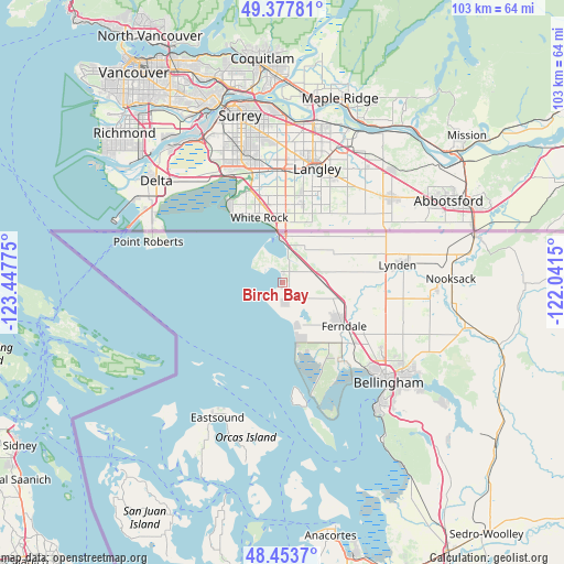
Birch Bay GPS coordinates[2]
48° 55' 4.404" North, 122° 44' 40.632" West
| Map corner | latitude | longitude |
|---|---|---|
| Upper-left | 49.37781°, | -123.44775° |
| Center: | 48.91789°, | -122.74462° |
| Lower-right: | 48.4537°, | -122.0415° |
| Map W x H: | 102.8×102.7 km | = 63.9×63.8mi |
| max Lat: | 71.29058° ⇑0.6% North |
| Birch Bay: | 48.91789° |
| min Lat: | ⇓99.4% South 19.06759° |
| min Long | Birch Bay | max Long |
| -171.73463° | -122.74462° | -66.98998° |
| W 2.7%⇐ | ⇒97.3% E |
Elevation
Elevation of Birch Bay is 2 m = 7 ft, and this is 292.8 m = 961 ft below average elevation for this country.
| Max E: |
3189 m = 10463 ft | 99.4% |
| Avg. | 294.8 m = 967 ft | |
| Birch Bay | 2 m = 7 ft | |
Min E: |
-60 m = -197 ft | 0.6% |
See also: United States elevation on elevation.city.
Geographical zone
Birch Bay is located in North temperate zone (between Tropic of Cancer and the Arctic Circle). Distance of this North polar circle is 1962 km =1219.1 mi to North.| Distance of | km | miles | from Birch Bay |
|---|---|---|---|
| North Pole | 4567.9 | 2838.4 | to North |
| Arctic Circle | 1962 | 1219.1 | to North |
| Tropic Cancer | 2833.2 | 1760.5 | to South |
| Equator | 5439.2 | 3379.8 | to South |


Nearby cities:
15 places around Birch Bay: (largest is in red/bold)
• Anacortes
46.1 km =28.6 mi,  167°
167°
• Bellingham
25.7 km =16 mi,  133°
133°
• Blaine
8.4 km =5.2 mi,  358°
358°
• Everson
29.4 km =18.3 mi,  89°
89°
• Ferndale
13.8 km =8.6 mi, 125°
• Friday Harbor
47.1 km =29.3 mi,  205°
205°
• Geneva
31.6 km =19.6 mi, 127°
• Lynden
21.6 km =13.4 mi,  81°
81°
• Marietta
18.9 km =11.7 mi,  140°
140°
• Marietta-Alderwood
20 km =12.4 mi, 135°
• Nooksack
30.9 km =19.2 mi, 87°
• Peaceful Valley
43.7 km =27.2 mi, 87°
• Point Roberts
25.5 km =15.8 mi,  287°
287°
• Sudden Valley
36.3 km =22.6 mi, 126°
• Sumas
36.2 km =22.5 mi, 75°
Sources, notices
• [Note1] Compared only with cities in United States existing in our database
• [Src1] Map data: © OpenStreetMap contributors (CC-BY-SA)
• [Src2] Other city data from geonames.org with taken over terms of usage.
• [Src3] Geographical zone / Annual Mean Temperature by Robert A. Rohde @ Wikipedia
