Sedro-Woolley geodata
Sedro-Woolley (Washington) is a populated place; located in United States in America/Los_Angeles (GMT-7) time zone. With population of 10,815 people, there are 4226 cities with bigger population in this country. Compared to other cities in United States, 99.1% of cities are located further ↓South; 95.8% of cities are located further →East and 89.1% of cities have higher elevation than Sedro-Woolley. Note1


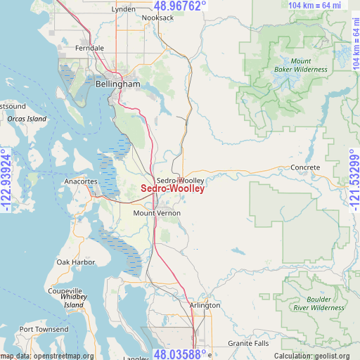
Sedro-Woolley GPS coordinates[2]
48° 30' 14.004" North, 122° 14' 9.996" West
| Map corner | latitude | longitude |
|---|---|---|
| Upper-left | 48.96762°, | -122.93924° |
| Center: | 48.50389°, | -122.23611° |
| Lower-right: | 48.03588°, | -121.53299° |
| Map W x H: | 103.6×103.6 km | = 64.4×64.4mi |
| max Lat: | 71.29058° ⇑0.9% North |
| Sedro-Woolley: | 48.50389° |
| min Lat: | ⇓99.1% South 19.06759° |
| min Long | Sedro-Woolley | max Long |
| -171.73463° | -122.23611° | -66.98998° |
| W 4.2%⇐ | ⇒95.8% E |
Elevation
Elevation of Sedro-Woolley is 18 m = 59 ft, and this is 276.8 m = 908 ft below average elevation for this country.
| Max E: |
3189 m = 10463 ft | 89.1% |
| Avg. | 294.8 m = 967 ft | |
| Sedro-Woolley | 18 m = 59 ft | |
Min E: |
-60 m = -197 ft | 10.9% |
See also: United States elevation on elevation.city.
Geographical zone
Sedro-Woolley is located in North temperate zone (between Tropic of Cancer and the Arctic Circle). Distance of this North polar circle is 2008 km =1247.7 mi to North.| Distance of | km | miles | from Sedro-Woolley |
|---|---|---|---|
| North Pole | 4613.9 | 2866.9 | to North |
| Arctic Circle | 2008 | 1247.7 | to North |
| Tropic Cancer | 2787.2 | 1731.9 | to South |
| Equator | 5393.1 | 3351.1 | to South |


Nearby cities:
15 places around Sedro-Woolley: (largest is in red/bold)
• Anacortes
27.8 km =17.3 mi,  271°
271°
• Arlington
34.9 km =21.7 mi,  166°
166°
• Arlington Heights
35.9 km =22.3 mi,  159°
159°
• Bay View
17.9 km =11.1 mi,  262°
262°
• Bellingham
33.9 km =21.1 mi,  326°
326°
• Big Lake
11.2 km =7 mi,  181°
181°
• Bryant
30 km =18.6 mi, 168°
• Burlington
7.3 km =4.5 mi,  244°
244°
• Clear Lake
4.4 km =2.7 mi, 178°
• Geneva
29.5 km =18.3 mi,  335°
335°
• La Conner
23.1 km =14.4 mi, 236°
• Lake Ketchum
25.7 km =16 mi,  198°
198°
• Mount Vernon
11.7 km =7.3 mi,  218°
218°
• Stanwood
30.9 km =19.2 mi, 198°
• Sudden Valley
25.7 km =16 mi, 341°
Sources, notices
• [Note1] Compared only with cities in United States existing in our database
• [Src1] Map data: © OpenStreetMap contributors (CC-BY-SA)
• [Src2] Other city data from geonames.org with taken over terms of usage.
• [Src3] Geographical zone / Annual Mean Temperature by Robert A. Rohde @ Wikipedia
