Garfield geodata
Garfield (Washington) is a populated place; located in United States in America/Los_Angeles (GMT-7) time zone. With population of 604 people, there are 19649 cities with bigger population in this country. Compared to other cities in United States, 96.7% of cities are located further ↓South; 89.9% of cities are located further →East and 91.5% of cities have lower elevation than Garfield. Note1


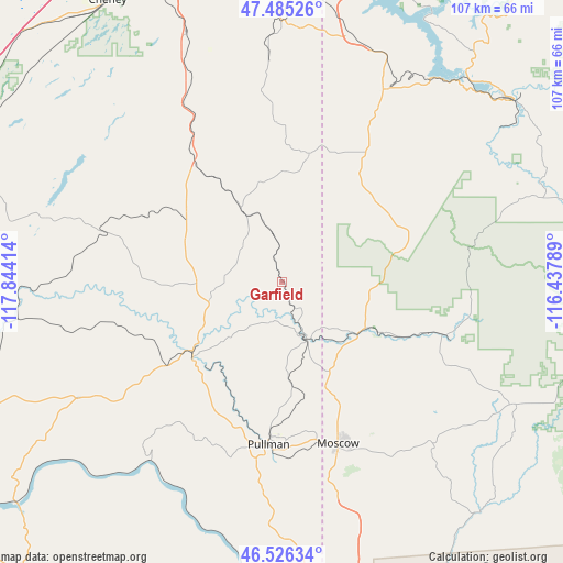
Garfield GPS coordinates[2]
47° 0' 28.62" North, 117° 8' 27.636" West
| Map corner | latitude | longitude |
|---|---|---|
| Upper-left | 47.48526°, | -117.84414° |
| Center: | 47.00795°, | -117.14101° |
| Lower-right: | 46.52634°, | -116.43789° |
| Map W x H: | 106.6×106.6 km | = 66.2×66.2mi |
| max Lat: | 71.29058° ⇑3.3% North |
| Garfield: | 47.00795° |
| min Lat: | ⇓96.7% South 19.06759° |
| min Long | Garfield | max Long |
| -171.73463° | -117.14101° | -66.98998° |
| W 10.1%⇐ | ⇒89.9% E |
Elevation
Elevation of Garfield is 753 m = 2470 ft, and this is 458.2 m = 1503 ft above average elevation for this country.
| Max E: |
3189 m = 10463 ft | 8.5% |
| Garfield | 753 m 2470 ft | |
| Avg. | 294.8 m = 967 ft | |
Min E: |
-60 m = -197 ft | 91.5% |
See also: United States elevation on elevation.city.
Geographical zone
Garfield is located in North temperate zone (between Tropic of Cancer and the Arctic Circle). Distance of this North polar circle is 2174.4 km =1351.1 mi to North.| Distance of | km | miles | from Garfield |
|---|---|---|---|
| North Pole | 4780.3 | 2970.3 | to North |
| Arctic Circle | 2174.4 | 1351.1 | to North |
| Tropic Cancer | 2620.9 | 1628.6 | to South |
| Equator | 5226.8 | 3247.8 | to South |


Nearby cities:
15 places around Garfield: (largest is in red/bold)
• Albion
25.5 km =15.8 mi,  199°
199°
• Colfax
22.1 km =13.7 mi,  230°
230°
• Deary
50.1 km =31.1 mi,  117°
117°
• Fairfield
42 km =26.1 mi,  356°
356°
• Genesee
53.4 km =33.2 mi,  162°
162°
• Moscow
32.5 km =20.2 mi, 160°
• Palouse
11.9 km =7.4 mi, 155°
• Plummer
41.1 km =25.5 mi,  27°
27°
• Potlatch
20.8 km =12.9 mi, 117°
• Pullman
30.9 km =19.2 mi,  185°
185°
• Rosalia
30.7 km =19.1 mi,  325°
325°
• Saint John
34.7 km =21.6 mi,  285°
285°
• Saint Maries
55.4 km =34.4 mi,  52°
52°
• Tekoa
24.5 km =15.2 mi,  12°
12°
• Troy
41.3 km =25.7 mi,  136°
136°
Sources, notices
• [Note1] Compared only with cities in United States existing in our database
• [Src1] Map data: © OpenStreetMap contributors (CC-BY-SA)
• [Src2] Other city data from geonames.org with taken over terms of usage.
• [Src3] Geographical zone / Annual Mean Temperature by Robert A. Rohde @ Wikipedia
