Saint John geodata
Saint John (Washington) is a populated place; located in United States in America/Los_Angeles (GMT-7) time zone. With population of 537 people, there are 20425 cities with bigger population in this country. Compared to other cities in United States, 96.7% of cities are located further ↓South; 90.4% of cities are located further →East and 89.6% of cities have lower elevation than Saint John. Note1


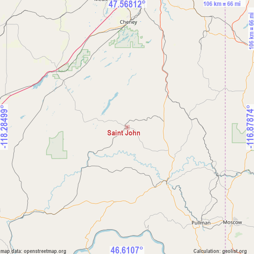
Saint John GPS coordinates[2]
47° 5' 29.616" North, 117° 34' 54.696" West
| Map corner | latitude | longitude |
|---|---|---|
| Upper-left | 47.56812°, | -118.28499° |
| Center: | 47.09156°, | -117.58186° |
| Lower-right: | 46.6107°, | -116.87874° |
| Map W x H: | 106.5×106.5 km | = 66.2×66.2mi |
| max Lat: | 71.29058° ⇑3.3% North |
| Saint John: | 47.09156° |
| min Lat: | ⇓96.7% South 19.06759° |
| min Long | Saint John | max Long |
| -171.73463° | -117.58186° | -66.98998° |
| W 9.6%⇐ | ⇒90.4% E |
Elevation
Elevation of Saint John is 597 m = 1959 ft, and this is 302.2 m = 991 ft above average elevation for this country.
| Max E: |
3189 m = 10463 ft | 10.4% |
| Saint John | 597 m 1959 ft | |
| Avg. | 294.8 m = 967 ft | |
Min E: |
-60 m = -197 ft | 89.6% |
See also: United States elevation on elevation.city.
Geographical zone
Saint John is located in North temperate zone (between Tropic of Cancer and the Arctic Circle). Distance of this North polar circle is 2165.1 km =1345.3 mi to North.| Distance of | km | miles | from Saint John |
|---|---|---|---|
| North Pole | 4771 | 2964.6 | to North |
| Arctic Circle | 2165.1 | 1345.3 | to North |
| Tropic Cancer | 2630.2 | 1634.3 | to South |
| Equator | 5236.1 | 3253.6 | to South |


Nearby cities:
15 places around Saint John: (largest is in red/bold)
• Albion
41.8 km =26 mi,  143°
143°
• Cheney
44 km =27.3 mi,  0°
0°
• Colfax
28.7 km =17.8 mi, 144°
• Fairchild Air Force Base
58.8 km =36.5 mi,  355°
355°
• Fairfield
45 km =28 mi,  43°
43°
• Four Lakes
52.2 km =32.4 mi, 358°
• Garfield
34.7 km =21.6 mi,  105°
105°
• Medical Lake
54.1 km =33.6 mi,  351°
351°
• Moscow
59.6 km =37 mi,  132°
132°
• Palouse
43.4 km =27 mi,  117°
117°
• Plummer
59 km =36.7 mi,  62°
62°
• Potlatch
55.2 km =34.3 mi, 110°
• Pullman
50.4 km =31.3 mi, 142°
• Rosalia
22.7 km =14.1 mi, 44°
• Tekoa
41.2 km =25.6 mi,  69°
69°
Sources, notices
• [Note1] Compared only with cities in United States existing in our database
• [Src1] Map data: © OpenStreetMap contributors (CC-BY-SA)
• [Src2] Other city data from geonames.org with taken over terms of usage.
• [Src3] Geographical zone / Annual Mean Temperature by Robert A. Rohde @ Wikipedia
