Mattawa geodata
Mattawa (Washington) is a populated place; located in United States in America/Los_Angeles (GMT-7) time zone. With population of 4,548 people, there are 7599 cities with bigger population in this country. Compared to other cities in United States, 96.2% of cities are located further ↓South; 92.8% of cities are located further →East and 58.2% of cities have lower elevation than Mattawa. Note1


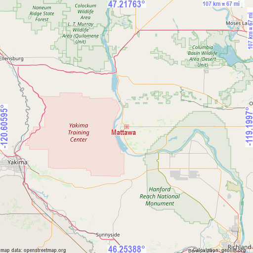
Mattawa GPS coordinates[2]
46° 44' 16.476" North, 119° 54' 10.152" West
| Map corner | latitude | longitude |
|---|---|---|
| Upper-left | 47.21763°, | -120.60595° |
| Center: | 46.73791°, | -119.90282° |
| Lower-right: | 46.25388°, | -119.1997° |
| Map W x H: | 107.2×107.2 km | = 66.6×66.6mi |
| max Lat: | 71.29058° ⇑3.8% North |
| Mattawa: | 46.73791° |
| min Lat: | ⇓96.2% South 19.06759° |
| min Long | Mattawa | max Long |
| -171.73463° | -119.90282° | -66.98998° |
| W 7.2%⇐ | ⇒92.8% E |
Elevation
Elevation of Mattawa is 231 m = 758 ft, and this is 63.8 m = 209 ft below average elevation for this country.
| Max E: |
3189 m = 10463 ft | 41.8% |
| Avg. | 294.8 m = 967 ft | |
| Mattawa | 231 m = 758 ft | |
Min E: |
-60 m = -197 ft | 58.2% |
See also: United States elevation on elevation.city.
Geographical zone
Mattawa is located in North temperate zone (between Tropic of Cancer and the Arctic Circle). Distance of this North polar circle is 2204.4 km =1369.8 mi to North.| Distance of | km | miles | from Mattawa |
|---|---|---|---|
| North Pole | 4810.3 | 2989 | to North |
| Arctic Circle | 2204.4 | 1369.8 | to North |
| Tropic Cancer | 2590.8 | 1609.8 | to South |
| Equator | 5196.8 | 3229.1 | to South |


Nearby cities:
15 places around Mattawa: (largest is in red/bold)
• Buena
46.5 km =28.9 mi,  222°
222°
• Desert Aire
6.6 km =4.1 mi,  189°
189°
• George
38.1 km =23.7 mi,  5°
5°
• Granger
49.1 km =30.5 mi,  206°
206°
• Kittitas
47.7 km =29.6 mi,  304°
304°
• Moxee City
42 km =26.1 mi,  240°
240°
• Royal City
27.5 km =17.1 mi,  48°
48°
• Selah
48.7 km =30.3 mi,  258°
258°
• Sunnyside
46.8 km =29.1 mi, 189°
• Terrace Heights
43.5 km =27 mi,  250°
250°
• Toppenish
50.7 km =31.5 mi, 217°
• Union Gap
48.1 km =29.9 mi, 245°
• Wapato
51 km =31.7 mi,  230°
230°
• Yakima
48.4 km =30.1 mi, 251°
• Zillah
46.3 km =28.8 mi, 216°
Sources, notices
• [Note1] Compared only with cities in United States existing in our database
• [Src1] Map data: © OpenStreetMap contributors (CC-BY-SA)
• [Src2] Other city data from geonames.org with taken over terms of usage.
• [Src3] Geographical zone / Annual Mean Temperature by Robert A. Rohde @ Wikipedia
