Mount Vernon geodata
Mount Vernon (Washington) is a seat of a second-order administrative division; located in United States in America/Los_Angeles (GMT-7) time zone. With population of 34,053 people, there are 1446 cities with bigger population in this country. Compared to other cities in United States, 99.1% of cities are located further ↓South; 96.2% of cities are located further →East and 85.4% of cities have higher elevation than Mount Vernon. Note1


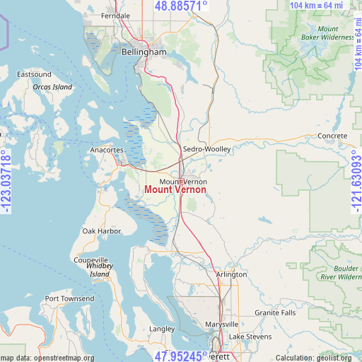
Mount Vernon GPS coordinates[2]
48° 25' 16.392" North, 122° 20' 2.58" West
| Map corner | latitude | longitude |
|---|---|---|
| Upper-left | 48.88571°, | -123.03718° |
| Center: | 48.42122°, | -122.33405° |
| Lower-right: | 47.95245°, | -121.63093° |
| Map W x H: | 103.8×103.8 km | = 64.5×64.5mi |
| max Lat: | 71.29058° ⇑0.9% North |
| Mount Vernon: | 48.42122° |
| min Lat: | ⇓99.1% South 19.06759° |
| min Long | Mount Vernon | max Long |
| -171.73463° | -122.33405° | -66.98998° |
| W 3.8%⇐ | ⇒96.2% E |
Elevation
Elevation of Mount Vernon is 27 m = 89 ft, and this is 267.8 m = 879 ft below average elevation for this country.
| Max E: |
3189 m = 10463 ft | 85.4% |
| Avg. | 294.8 m = 967 ft | |
| Mount Vernon | 27 m = 89 ft | |
Min E: |
-60 m = -197 ft | 14.6% |
See also: United States elevation on elevation.city.
Geographical zone
Mount Vernon is located in North temperate zone (between Tropic of Cancer and the Arctic Circle). Distance of this North polar circle is 2017.2 km =1253.4 mi to North.| Distance of | km | miles | from Mount Vernon |
|---|---|---|---|
| North Pole | 4623.1 | 2872.7 | to North |
| Arctic Circle | 2017.2 | 1253.4 | to North |
| Tropic Cancer | 2778 | 1726.2 | to South |
| Equator | 5383.9 | 3345.4 | to South |


Nearby cities:
15 places around Mount Vernon: (largest is in red/bold)
• Anacortes
22.9 km =14.2 mi,  296°
296°
• Arlington
29.2 km =18.1 mi,  148°
148°
• Ault Field
26.8 km =16.7 mi,  249°
249°
• Bay View
12.7 km =7.9 mi, 303°
• Big Lake
7.1 km =4.4 mi,  106°
106°
• Bryant
24.1 km =15 mi, 147°
• Burlington
6.1 km =3.8 mi,  5°
5°
• Camano
31 km =19.3 mi,  207°
207°
• Clear Lake
8.8 km =5.5 mi,  57°
57°
• La Conner
12.5 km =7.8 mi, 253°
• Lake Ketchum
15.2 km =9.4 mi,  182°
182°
• Oak Harbor
26.9 km =16.7 mi,  238°
238°
• Sedro-Woolley
11.7 km =7.3 mi,  38°
38°
• Stanwood
20.2 km =12.6 mi,  187°
187°
• Warm Beach
28 km =17.4 mi, 184°
Sources, notices
• [Note1] Compared only with cities in United States existing in our database
• [Src1] Map data: © OpenStreetMap contributors (CC-BY-SA)
• [Src2] Other city data from geonames.org with taken over terms of usage.
• [Src3] Geographical zone / Annual Mean Temperature by Robert A. Rohde @ Wikipedia
