Anacortes geodata
Anacortes (Washington) is a populated place; located in United States in America/Los_Angeles (GMT-7) time zone. With population of 16,403 people, there are 2993 cities with bigger population in this country. Compared to other cities in United States, 99.1% of cities are located further ↓South; 97% of cities are located further →East and 98.8% of cities have higher elevation than Anacortes. Note1


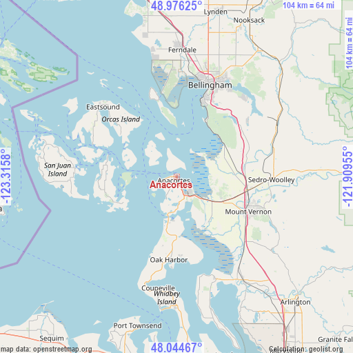
Anacortes GPS coordinates[2]
48° 30' 45.36" North, 122° 36' 45.612" West
| Map corner | latitude | longitude |
|---|---|---|
| Upper-left | 48.97625°, | -123.3158° |
| Center: | 48.5126°, | -122.61267° |
| Lower-right: | 48.04467°, | -121.90955° |
| Map W x H: | 103.6×103.6 km | = 64.4×64.4mi |
| max Lat: | 71.29058° ⇑0.9% North |
| Anacortes: | 48.5126° |
| min Lat: | ⇓99.1% South 19.06759° |
| min Long | Anacortes | max Long |
| -171.73463° | -122.61267° | -66.98998° |
| W 3%⇐ | ⇒97% E |
Elevation
Elevation of Anacortes is 4 m = 13 ft, and this is 290.8 m = 954 ft below average elevation for this country.
| Max E: |
3189 m = 10463 ft | 98.8% |
| Avg. | 294.8 m = 967 ft | |
| Anacortes | 4 m = 13 ft | |
Min E: |
-60 m = -197 ft | 1.2% |
See also: United States elevation on elevation.city.
Geographical zone
Anacortes is located in North temperate zone (between Tropic of Cancer and the Arctic Circle). Distance of this North polar circle is 2007.1 km =1247.2 mi to North.| Distance of | km | miles | from Anacortes |
|---|---|---|---|
| North Pole | 4613 | 2866.4 | to North |
| Arctic Circle | 2007.1 | 1247.2 | to North |
| Tropic Cancer | 2788.2 | 1732.5 | to South |
| Equator | 5394.1 | 3351.7 | to South |


Nearby cities:
15 places around Anacortes: (largest is in red/bold)
• Ault Field
19.9 km =12.4 mi,  193°
193°
• Bay View
10.5 km =6.5 mi,  107°
107°
• Bellingham
28.9 km =18 mi,  18°
18°
• Big Lake
30 km =18.6 mi, 114°
• Burlington
21.6 km =13.4 mi,  100°
100°
• Clear Lake
28.4 km =17.6 mi, 100°
• Friday Harbor
29.9 km =18.6 mi,  274°
274°
• Geneva
30.2 km =18.8 mi,  30°
30°
• La Conner
16.2 km =10.1 mi,  148°
148°
• Marietta
30.6 km =19 mi,  4°
4°
• Marietta-Alderwood
31.1 km =19.3 mi,  8°
8°
• Mount Vernon
22.9 km =14.2 mi,  116°
116°
• Oak Harbor
24.5 km =15.2 mi, 185°
• Sedro-Woolley
27.8 km =17.3 mi,  91°
91°
• Sudden Valley
30.5 km =19 mi,  39°
39°
Sources, notices
• [Note1] Compared only with cities in United States existing in our database
• [Src1] Map data: © OpenStreetMap contributors (CC-BY-SA)
• [Src2] Other city data from geonames.org with taken over terms of usage.
• [Src3] Geographical zone / Annual Mean Temperature by Robert A. Rohde @ Wikipedia
