Quilcene geodata
Quilcene (Washington) is a populated place; located in United States in America/Los_Angeles (GMT-7) time zone. With population of 596 people, there are 19749 cities with bigger population in this country. Compared to other cities in United States, 98.3% of cities are located further ↓South; 97.7% of cities are located further →East and 91.5% of cities have higher elevation than Quilcene. Note1


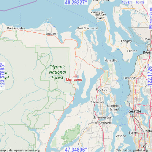
Quilcene GPS coordinates[2]
47° 49' 20.316" North, 122° 52' 32.592" West
| Map corner | latitude | longitude |
|---|---|---|
| Upper-left | 48.29227°, | -123.57885° |
| Center: | 47.82231°, | -122.87572° |
| Lower-right: | 47.34806°, | -122.1726° |
| Map W x H: | 105×105 km | = 65.2×65.2mi |
| max Lat: | 71.29058° ⇑1.7% North |
| Quilcene: | 47.82231° |
| min Lat: | ⇓98.3% South 19.06759° |
| min Long | Quilcene | max Long |
| -171.73463° | -122.87572° | -66.98998° |
| W 2.3%⇐ | ⇒97.7% E |
Elevation
Elevation of Quilcene is 13 m = 43 ft, and this is 281.8 m = 925 ft below average elevation for this country.
| Max E: |
3189 m = 10463 ft | 91.5% |
| Avg. | 294.8 m = 967 ft | |
| Quilcene | 13 m = 43 ft | |
Min E: |
-60 m = -197 ft | 8.5% |
See also: United States elevation on elevation.city.
Geographical zone
Quilcene is located in North temperate zone (between Tropic of Cancer and the Arctic Circle). Distance of this North polar circle is 2083.8 km =1294.8 mi to North.| Distance of | km | miles | from Quilcene |
|---|---|---|---|
| North Pole | 4689.7 | 2914 | to North |
| Arctic Circle | 2083.8 | 1294.8 | to North |
| Tropic Cancer | 2711.4 | 1684.8 | to South |
| Equator | 5317.3 | 3304 | to South |


Nearby cities:
15 places around Quilcene: (largest is in red/bold)
• Bangor Trident Base
16.4 km =10.2 mi,  132°
132°
• Brinnon
16 km =9.9 mi,  186°
186°
• Chico
26.5 km =16.5 mi,  152°
152°
• Erlands Point-Kitsap Lake
28.2 km =17.5 mi, 152°
• Hansville
26.3 km =16.3 mi,  65°
65°
• Indianola
27.5 km =17.1 mi,  107°
107°
• Keyport
23.3 km =14.5 mi, 125°
• Kingston
28.3 km =17.6 mi,  95°
95°
• Lofall
16.3 km =10.1 mi,  94°
94°
• Port Hadlock-Irondale
24.3 km =15.1 mi,  16°
16°
• Port Ludlow
18.4 km =11.4 mi,  51°
51°
• Poulsbo
19.6 km =12.2 mi,  119°
119°
• Seabeck
20.6 km =12.8 mi,  170°
170°
• Silverdale
24 km =14.9 mi, 145°
• Suquamish
26.2 km =16.3 mi, 112°
Sources, notices
• [Note1] Compared only with cities in United States existing in our database
• [Src1] Map data: © OpenStreetMap contributors (CC-BY-SA)
• [Src2] Other city data from geonames.org with taken over terms of usage.
• [Src3] Geographical zone / Annual Mean Temperature by Robert A. Rohde @ Wikipedia
