Satsop geodata
Satsop (Washington) is a populated place; located in United States in America/Los_Angeles (GMT-7) time zone. With population of 675 people, there are 18918 cities with bigger population in this country. Compared to other cities in United States, 96.6% of cities are located further ↓South; 98.3% of cities are located further →East and 93% of cities have higher elevation than Satsop. Note1


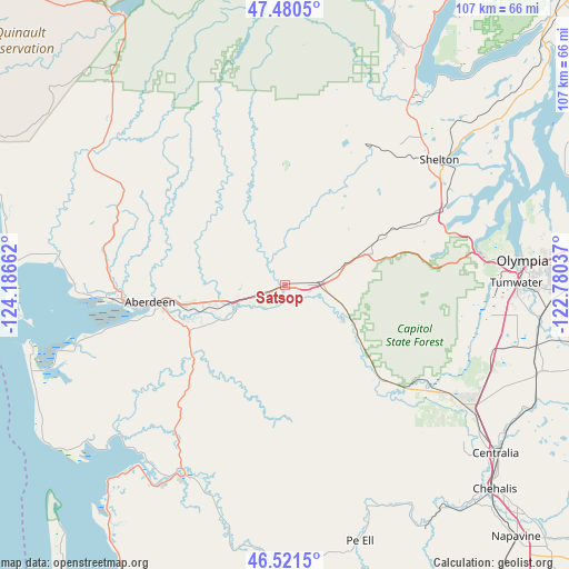
Satsop GPS coordinates[2]
47° 0' 11.34" North, 123° 29' 0.564" West
| Map corner | latitude | longitude |
|---|---|---|
| Upper-left | 47.4805°, | -124.18662° |
| Center: | 47.00315°, | -123.48349° |
| Lower-right: | 46.5215°, | -122.78037° |
| Map W x H: | 106.6×106.6 km | = 66.2×66.2mi |
| max Lat: | 71.29058° ⇑3.4% North |
| Satsop: | 47.00315° |
| min Lat: | ⇓96.6% South 19.06759° |
| min Long | Satsop | max Long |
| -171.73463° | -123.48349° | -66.98998° |
| W 1.7%⇐ | ⇒98.3% E |
Elevation
Elevation of Satsop is 11 m = 36 ft, and this is 283.8 m = 931 ft below average elevation for this country.
| Max E: |
3189 m = 10463 ft | 93% |
| Avg. | 294.8 m = 967 ft | |
| Satsop | 11 m = 36 ft | |
Min E: |
-60 m = -197 ft | 7% |
See also: United States elevation on elevation.city.
Geographical zone
Satsop is located in North temperate zone (between Tropic of Cancer and the Arctic Circle). Distance of this North polar circle is 2174.9 km =1351.4 mi to North.| Distance of | km | miles | from Satsop |
|---|---|---|---|
| North Pole | 4780.8 | 2970.7 | to North |
| Arctic Circle | 2174.9 | 1351.4 | to North |
| Tropic Cancer | 2620.3 | 1628.2 | to South |
| Equator | 5226.3 | 3247.5 | to South |


Nearby cities:
15 places around Satsop: (largest is in red/bold)
• Aberdeen
25.4 km =15.8 mi,  263°
263°
• Brady
2.3 km =1.4 mi,  249°
249°
• Central Park
16.2 km =10.1 mi, 258°
• Cosmopolis
22.7 km =14.1 mi, 256°
• Elma
5.7 km =3.5 mi,  89°
89°
• Grand Mound
43.1 km =26.8 mi,  123°
123°
• Hoquiam
30.9 km =19.2 mi,  265°
265°
• McCleary
17.4 km =10.8 mi,  71°
71°
• Montesano
9.4 km =5.8 mi, 254°
• Oakville
26.3 km =16.3 mi,  133°
133°
• Raymond
40 km =24.9 mi,  208°
208°
• Rochester
35.7 km =22.2 mi, 124°
• Shelton
37.3 km =23.2 mi,  50°
50°
• Skokomish
44.2 km =27.5 mi,  33°
33°
• Tumwater
43.5 km =27 mi, 89°
Sources, notices
• [Note1] Compared only with cities in United States existing in our database
• [Src1] Map data: © OpenStreetMap contributors (CC-BY-SA)
• [Src2] Other city data from geonames.org with taken over terms of usage.
• [Src3] Geographical zone / Annual Mean Temperature by Robert A. Rohde @ Wikipedia
