McCleary geodata
McCleary (Washington) is a populated place; located in United States in America/Los_Angeles (GMT-7) time zone. With population of 1,618 people, there are 13231 cities with bigger population in this country. Compared to other cities in United States, 96.7% of cities are located further ↓South; 98.1% of cities are located further →East and 73.5% of cities have higher elevation than McCleary. Note1


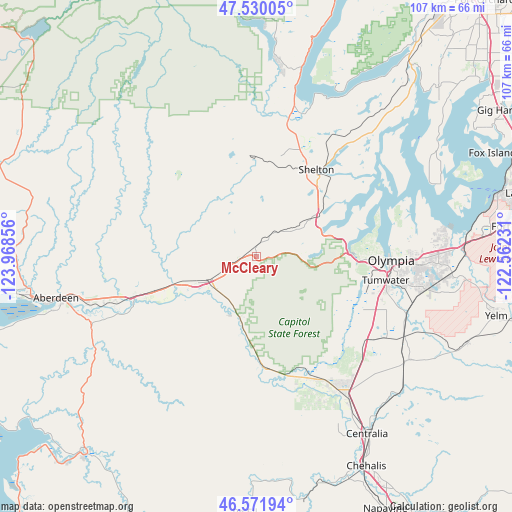
McCleary GPS coordinates[2]
47° 3' 11.34" North, 123° 15' 55.548" West
| Map corner | latitude | longitude |
|---|---|---|
| Upper-left | 47.53005°, | -123.96856° |
| Center: | 47.05315°, | -123.26543° |
| Lower-right: | 46.57194°, | -122.56231° |
| Map W x H: | 106.5×106.5 km | = 66.2×66.2mi |
| max Lat: | 71.29058° ⇑3.3% North |
| McCleary: | 47.05315° |
| min Lat: | ⇓96.7% South 19.06759° |
| min Long | McCleary | max Long |
| -171.73463° | -123.26543° | -66.98998° |
| W 1.9%⇐ | ⇒98.1% E |
Elevation
Elevation of McCleary is 80 m = 262 ft, and this is 214.8 m = 705 ft below average elevation for this country.
| Max E: |
3189 m = 10463 ft | 73.5% |
| Avg. | 294.8 m = 967 ft | |
| McCleary | 80 m = 262 ft | |
Min E: |
-60 m = -197 ft | 26.5% |
See also: United States elevation on elevation.city.
Geographical zone
McCleary is located in North temperate zone (between Tropic of Cancer and the Arctic Circle). Distance of this North polar circle is 2169.4 km =1348 mi to North.| Distance of | km | miles | from McCleary |
|---|---|---|---|
| North Pole | 4775.2 | 2967.2 | to North |
| Arctic Circle | 2169.4 | 1348 | to North |
| Tropic Cancer | 2625.9 | 1631.7 | to South |
| Equator | 5231.8 | 3250.9 | to South |


Nearby cities:
15 places around McCleary: (largest is in red/bold)
• Brady
19.7 km =12.2 mi,  251°
251°
• Central Park
33.6 km =20.9 mi, 254°
• Elma
12.2 km =7.6 mi,  243°
243°
• Grand Mound
35.3 km =21.9 mi,  146°
146°
• Lacey
33.6 km =20.9 mi,  93°
93°
• Montesano
26.8 km =16.7 mi, 252°
• Oakville
23.8 km =14.8 mi,  173°
173°
• Olympia
27.7 km =17.2 mi, 93°
• Rochester
28.8 km =17.9 mi, 153°
• Satsop
17.4 km =10.8 mi, 251°
• Shelton
21.9 km =13.6 mi,  34°
34°
• Skokomish
32.2 km =20 mi,  14°
14°
• Tanglewilde
36.6 km =22.7 mi, 90°
• Tumwater
27.5 km =17.1 mi,  100°
100°
• Union
35.8 km =22.2 mi,  20°
20°
Sources, notices
• [Note1] Compared only with cities in United States existing in our database
• [Src1] Map data: © OpenStreetMap contributors (CC-BY-SA)
• [Src2] Other city data from geonames.org with taken over terms of usage.
• [Src3] Geographical zone / Annual Mean Temperature by Robert A. Rohde @ Wikipedia
