Inglewood-Finn Hill geodata
Inglewood-Finn Hill (Washington) is a populated place; located in United States in America/Los_Angeles (GMT-7) time zone. With population of 22,707 people, there are 2231 cities with bigger population in this country. Compared to other cities in United States, 98.1% of cities are located further ↓South; 95.7% of cities are located further →East and 67.1% of cities have higher elevation than Inglewood-Finn Hill. Note1


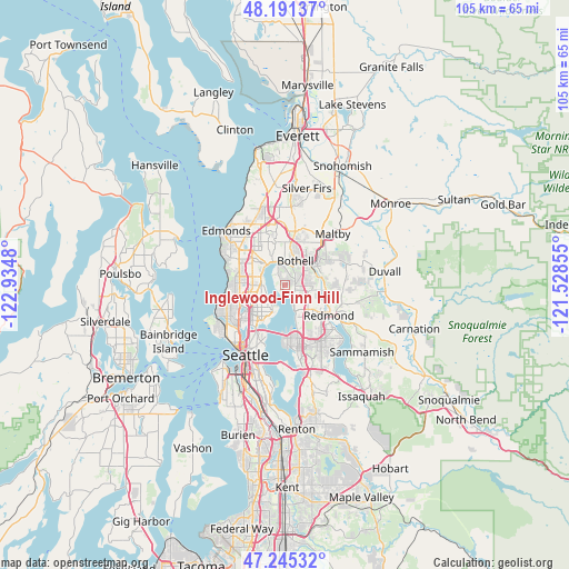
Inglewood-Finn Hill GPS coordinates[2]
47° 43' 13.764" North, 122° 13' 54.012" West
| Map corner | latitude | longitude |
|---|---|---|
| Upper-left | 48.19137°, | -122.9348° |
| Center: | 47.72049°, | -122.23167° |
| Lower-right: | 47.24532°, | -121.52855° |
| Map W x H: | 105.2×105.2 km | = 65.4×65.4mi |
| max Lat: | 71.29058° ⇑1.9% North |
| Inglewood-Finn Hill: | 47.72049° |
| min Lat: | ⇓98.1% South 19.06759° |
| min Long | Inglewood-Finn | max Long |
| -171.73463° | -122.23167° | -66.98998° |
| W 4.3%⇐ | ⇒95.7% E |
Elevation
Elevation of Inglewood-Finn Hill is 117 m = 384 ft, and this is 177.8 m = 583 ft below average elevation for this country.
| Max E: |
3189 m = 10463 ft | 67.1% |
| Avg. | 294.8 m = 967 ft | |
| Inglewood-Finn Hill | 117 m = 384 ft | |
Min E: |
-60 m = -197 ft | 32.9% |
See also: United States elevation on elevation.city.
Geographical zone
Inglewood-Finn Hill is located in North temperate zone (between Tropic of Cancer and the Arctic Circle). Distance of this North polar circle is 2095.2 km =1301.9 mi to North.| Distance of | km | miles | from Inglewood-Finn Hill |
|---|---|---|---|
| North Pole | 4701 | 2921.1 | to North |
| Arctic Circle | 2095.2 | 1301.9 | to North |
| Tropic Cancer | 2700.1 | 1677.8 | to South |
| Equator | 5306 | 3297 | to South |


Nearby cities:
15 places around Inglewood-Finn Hill: (largest is in red/bold)
• Bothell
5 km =3.1 mi,  22°
22°
• Bothell East
10.2 km =6.3 mi, 20°
• Bothell West
9.5 km =5.9 mi,  355°
355°
• Brier
7.8 km =4.8 mi,  335°
335°
• Clyde Hill
9.9 km =6.2 mi,  174°
174°
• Kenmore
4.2 km =2.6 mi,  347°
347°
• Kingsgate
4 km =2.5 mi,  79°
79°
• Kirkland
4.7 km =2.9 mi,  158°
158°
• Lake Forest Park
5.5 km =3.4 mi,  317°
317°
• Medina
11.1 km =6.9 mi,  178°
178°
• Mountlake Terrace
9.5 km =5.9 mi, 322°
• Redmond
9.7 km =6 mi,  122°
122°
• Shoreline
9.1 km =5.7 mi,  295°
295°
• Woodinville
6.3 km =3.9 mi,  53°
53°
• Yarrow Point
8.3 km =5.2 mi, 172°
Sources, notices
• [Note1] Compared only with cities in United States existing in our database
• [Src1] Map data: © OpenStreetMap contributors (CC-BY-SA)
• [Src2] Other city data from geonames.org with taken over terms of usage.
• [Src3] Geographical zone / Annual Mean Temperature by Robert A. Rohde @ Wikipedia
