Wapato geodata
Wapato (Washington) is a populated place; located in United States in America/Los_Angeles (GMT-7) time zone. With population of 5,068 people, there are 7114 cities with bigger population in this country. Compared to other cities in United States, 95.7% of cities are located further ↓South; 93.2% of cities are located further →East and 64.8% of cities have lower elevation than Wapato. Note1


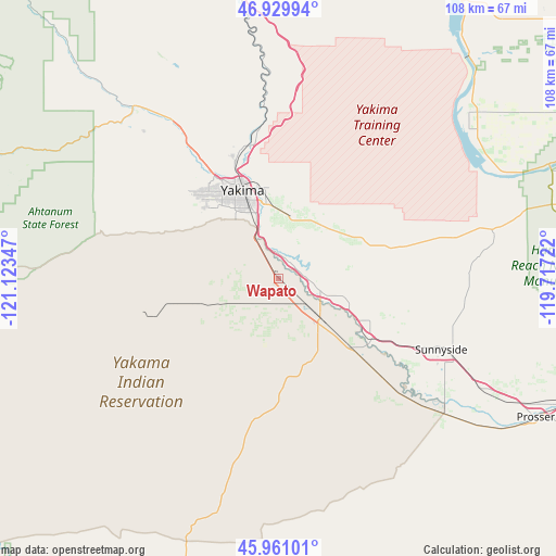
Wapato GPS coordinates[2]
46° 26' 51.468" North, 120° 25' 13.224" West
| Map corner | latitude | longitude |
|---|---|---|
| Upper-left | 46.92994°, | -121.12347° |
| Center: | 46.44763°, | -120.42034° |
| Lower-right: | 45.96101°, | -119.71722° |
| Map W x H: | 107.7×107.7 km | = 66.9×66.9mi |
| max Lat: | 71.29058° ⇑4.3% North |
| Wapato: | 46.44763° |
| min Lat: | ⇓95.7% South 19.06759° |
| min Long | Wapato | max Long |
| -171.73463° | -120.42034° | -66.98998° |
| W 6.8%⇐ | ⇒93.2% E |
Elevation
Elevation of Wapato is 261 m = 856 ft, and this is 33.8 m = 111 ft below average elevation for this country.
| Max E: |
3189 m = 10463 ft | 35.2% |
| Avg. | 294.8 m = 967 ft | |
| Wapato | 261 m = 856 ft | |
Min E: |
-60 m = -197 ft | 64.8% |
See also: United States elevation on elevation.city.
Geographical zone
Wapato is located in North temperate zone (between Tropic of Cancer and the Arctic Circle). Distance of this North polar circle is 2236.7 km =1389.8 mi to North.| Distance of | km | miles | from Wapato |
|---|---|---|---|
| North Pole | 4842.6 | 3009.1 | to North |
| Arctic Circle | 2236.7 | 1389.8 | to North |
| Tropic Cancer | 2558.6 | 1589.8 | to South |
| Equator | 5164.5 | 3209.1 | to South |


Nearby cities:
15 places around Wapato: (largest is in red/bold)
• Ahtanum
19.8 km =12.3 mi,  308°
308°
• Buena
8.5 km =5.3 mi,  104°
104°
• Gleed
27.7 km =17.2 mi,  327°
327°
• Granger
21.4 km =13.3 mi,  123°
123°
• Harrah
10.6 km =6.6 mi,  243°
243°
• Moxee City
12.1 km =7.5 mi,  13°
13°
• Selah
24.4 km =15.2 mi,  339°
339°
• Summitview
23.7 km =14.7 mi, 314°
• Terrace Heights
17.7 km =11 mi,  355°
355°
• Toppenish
11.6 km =7.2 mi,  132°
132°
• Union Gap
12.9 km =8 mi, 341°
• West Valley
21.4 km =13.3 mi,  318°
318°
• White Swan
24.9 km =15.5 mi,  253°
253°
• Yakima
18.4 km =11.4 mi, 339°
• Zillah
13.2 km =8.2 mi,  112°
112°
Sources, notices
• [Note1] Compared only with cities in United States existing in our database
• [Src1] Map data: © OpenStreetMap contributors (CC-BY-SA)
• [Src2] Other city data from geonames.org with taken over terms of usage.
• [Src3] Geographical zone / Annual Mean Temperature by Robert A. Rohde @ Wikipedia
