Yakima geodata
Yakima (Washington) is a seat of a second-order administrative division; located in United States in America/Los_Angeles (GMT-7) time zone. With population of 93,701 people, there are 387 cities with bigger population in this country. Compared to other cities in United States, 96% of cities are located further ↓South; 93.3% of cities are located further →East and 76.6% of cities have lower elevation than Yakima. Note1


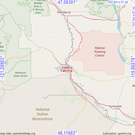
Yakima GPS coordinates[2]
46° 36' 7.452" North, 120° 30' 21.24" West
| Map corner | latitude | longitude |
|---|---|---|
| Upper-left | 47.08301°, | -121.20903° |
| Center: | 46.60207°, | -120.5059° |
| Lower-right: | 46.11683°, | -119.80278° |
| Map W x H: | 107.4×107.4 km | = 66.7×66.7mi |
| max Lat: | 71.29058° ⇑4% North |
| Yakima: | 46.60207° |
| min Lat: | ⇓96% South 19.06759° |
| min Long | Yakima | max Long |
| -171.73463° | -120.5059° | -66.98998° |
| W 6.7%⇐ | ⇒93.3% E |
Elevation
Elevation of Yakima is 325 m = 1066 ft, and this is 30.2 m = 99 ft above average elevation for this country.
| Max E: |
3189 m = 10463 ft | 23.4% |
| Yakima | 325 m 1066 ft | |
| Avg. | 294.8 m = 967 ft | |
Min E: |
-60 m = -197 ft | 76.6% |
See also: Yakima elevation on elevation.city.
Geographical zone
Yakima is located in North temperate zone (between Tropic of Cancer and the Arctic Circle). Distance of this North polar circle is 2219.5 km =1379.1 mi to North.| Distance of | km | miles | from Yakima |
|---|---|---|---|
| North Pole | 4825.4 | 2998.4 | to North |
| Arctic Circle | 2219.5 | 1379.1 | to North |
| Tropic Cancer | 2575.7 | 1600.5 | to South |
| Equator | 5181.7 | 3219.8 | to South |


Nearby cities:
15 places around Yakima: (largest is in red/bold)
• Ahtanum
10.1 km =6.3 mi,  241°
241°
• Buena
24.3 km =15.1 mi,  142°
142°
• Gleed
10.3 km =6.4 mi,  307°
307°
• Harrah
22.2 km =13.8 mi,  187°
187°
• Moxee City
10.8 km =6.7 mi,  119°
119°
• Naches
20.6 km =12.8 mi, 314°
• Selah
6.1 km =3.8 mi,  342°
342°
• Summitview
10.4 km =6.5 mi,  266°
266°
• Terrace Heights
5.1 km =3.2 mi,  84°
84°
• Tieton
22 km =13.7 mi,  300°
300°
• Toppenish
29.2 km =18.1 mi,  148°
148°
• Union Gap
5.5 km =3.4 mi, 154°
• Wapato
18.4 km =11.4 mi,  159°
159°
• West Valley
7.7 km =4.8 mi,  261°
261°
• Zillah
29 km =18 mi, 139°
Sources, notices
• [Note1] Compared only with cities in United States existing in our database
• [Src1] Map data: © OpenStreetMap contributors (CC-BY-SA)
• [Src2] Other city data from geonames.org with taken over terms of usage.
• [Src3] Geographical zone / Annual Mean Temperature by Robert A. Rohde @ Wikipedia
