Zillah geodata
Zillah (Washington) is a populated place; located in United States in America/Los_Angeles (GMT-7) time zone. With population of 3,138 people, there are 9403 cities with bigger population in this country. Compared to other cities in United States, 95.6% of cities are located further ↓South; 93.1% of cities are located further →East and 61.4% of cities have lower elevation than Zillah. Note1


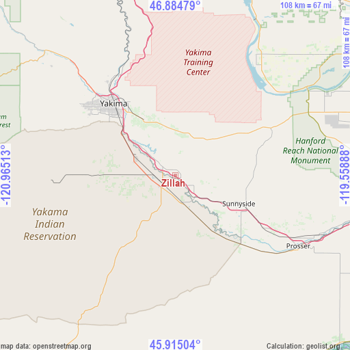
Zillah GPS coordinates[2]
46° 24' 7.452" North, 120° 15' 43.2" West
| Map corner | latitude | longitude |
|---|---|---|
| Upper-left | 46.88479°, | -120.96513° |
| Center: | 46.40207°, | -120.262° |
| Lower-right: | 45.91504°, | -119.55888° |
| Map W x H: | 107.8×107.8 km | = 67×67mi |
| max Lat: | 71.29058° ⇑4.4% North |
| Zillah: | 46.40207° |
| min Lat: | ⇓95.6% South 19.06759° |
| min Long | Zillah | max Long |
| -171.73463° | -120.262° | -66.98998° |
| W 6.9%⇐ | ⇒93.1% E |
Elevation
Elevation of Zillah is 246 m = 807 ft, and this is 48.8 m = 160 ft below average elevation for this country.
| Max E: |
3189 m = 10463 ft | 38.6% |
| Avg. | 294.8 m = 967 ft | |
| Zillah | 246 m = 807 ft | |
Min E: |
-60 m = -197 ft | 61.4% |
See also: United States elevation on elevation.city.
Geographical zone
Zillah is located in North temperate zone (between Tropic of Cancer and the Arctic Circle). Distance of this North polar circle is 2241.7 km =1392.9 mi to North.| Distance of | km | miles | from Zillah |
|---|---|---|---|
| North Pole | 4847.6 | 3012.2 | to North |
| Arctic Circle | 2241.7 | 1392.9 | to North |
| Tropic Cancer | 2553.5 | 1586.7 | to South |
| Equator | 5159.4 | 3205.9 | to South |


Nearby cities:
15 places around Zillah: (largest is in red/bold)
• Ahtanum
32.7 km =20.3 mi,  302°
302°
• Buena
4.9 km =3 mi,  306°
306°
• Grandview
32.4 km =20.1 mi,  121°
121°
• Granger
8.8 km =5.5 mi,  139°
139°
• Harrah
21.6 km =13.4 mi,  270°
270°
• Mabton
29.1 km =18.1 mi, 135°
• Moxee City
19.2 km =11.9 mi,  331°
331°
• Satus
17 km =10.6 mi,  149°
149°
• Sunnyside
21.3 km =13.2 mi,  114°
114°
• Terrace Heights
26.5 km =16.5 mi, 329°
• Toppenish
4.5 km =2.8 mi,  232°
232°
• Union Gap
23.8 km =14.8 mi,  316°
316°
• Wapato
13.2 km =8.2 mi,  292°
292°
• West Valley
33.7 km =20.9 mi, 308°
• Yakima
29 km =18 mi, 319°
Sources, notices
• [Note1] Compared only with cities in United States existing in our database
• [Src1] Map data: © OpenStreetMap contributors (CC-BY-SA)
• [Src2] Other city data from geonames.org with taken over terms of usage.
• [Src3] Geographical zone / Annual Mean Temperature by Robert A. Rohde @ Wikipedia
