Gleed geodata
Gleed (Washington) is a populated place; located in United States in America/Los_Angeles (GMT-7) time zone. With population of 2,906 people, there are 9789 cities with bigger population in this country. Compared to other cities in United States, 96.1% of cities are located further ↓South; 93.4% of cities are located further →East and 82.2% of cities have lower elevation than Gleed. Note1


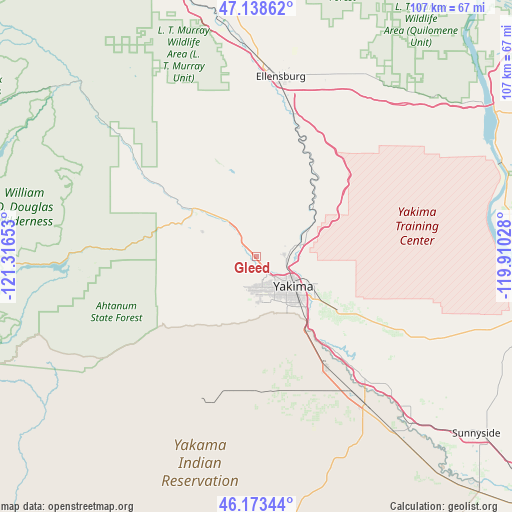
Gleed GPS coordinates[2]
46° 39' 29.448" North, 120° 36' 48.24" West
| Map corner | latitude | longitude |
|---|---|---|
| Upper-left | 47.13862°, | -121.31653° |
| Center: | 46.65818°, | -120.6134° |
| Lower-right: | 46.17344°, | -119.91028° |
| Map W x H: | 107.3×107.3 km | = 66.7×66.7mi |
| max Lat: | 71.29058° ⇑3.9% North |
| Gleed: | 46.65818° |
| min Lat: | ⇓96.1% South 19.06759° |
| min Long | Gleed | max Long |
| -171.73463° | -120.6134° | -66.98998° |
| W 6.6%⇐ | ⇒93.4% E |
Elevation
Elevation of Gleed is 379 m = 1243 ft, and this is 84.2 m = 276 ft above average elevation for this country.
| Max E: |
3189 m = 10463 ft | 17.8% |
| Gleed | 379 m 1243 ft | |
| Avg. | 294.8 m = 967 ft | |
Min E: |
-60 m = -197 ft | 82.2% |
See also: United States elevation on elevation.city.
Geographical zone
Gleed is located in North temperate zone (between Tropic of Cancer and the Arctic Circle). Distance of this North polar circle is 2213.3 km =1375.3 mi to North.| Distance of | km | miles | from Gleed |
|---|---|---|---|
| North Pole | 4819.2 | 2994.5 | to North |
| Arctic Circle | 2213.3 | 1375.3 | to North |
| Tropic Cancer | 2582 | 1604.4 | to South |
| Equator | 5187.9 | 3223.6 | to South |


Nearby cities:
15 places around Gleed: (largest is in red/bold)
• Ahtanum
11 km =6.8 mi,  183°
183°
• Buena
34.3 km =21.3 mi,  138°
138°
• Ellensburg
37.9 km =23.5 mi,  7°
7°
• Harrah
28.7 km =17.8 mi,  169°
169°
• Moxee City
21.1 km =13.1 mi,  123°
123°
• Naches
10.4 km =6.5 mi,  320°
320°
• Selah
6.4 km =4 mi,  94°
94°
• Summitview
7.2 km =4.5 mi,  197°
197°
• Terrace Heights
14.5 km =9 mi,  113°
113°
• Tieton
11.9 km =7.4 mi,  294°
294°
• Union Gap
15.4 km =9.6 mi, 136°
• Wapato
27.7 km =17.2 mi,  147°
147°
• West Valley
7.4 km =4.6 mi, 175°
• White Swan
31.9 km =19.8 mi, 196°
• Yakima
10.3 km =6.4 mi,  127°
127°
Sources, notices
• [Note1] Compared only with cities in United States existing in our database
• [Src1] Map data: © OpenStreetMap contributors (CC-BY-SA)
• [Src2] Other city data from geonames.org with taken over terms of usage.
• [Src3] Geographical zone / Annual Mean Temperature by Robert A. Rohde @ Wikipedia
