Cody geodata
Cody (Wyoming) is a seat of a second-order administrative division; located in United States in America/Denver (GMT-6) time zone. With population of 9,792 people, there are 4528 cities with bigger population in this country. Compared to other cities in United States, 90.6% of cities are located further ↓South; 85.4% of cities are located further →East and 96.9% of cities have lower elevation than Cody. Note1


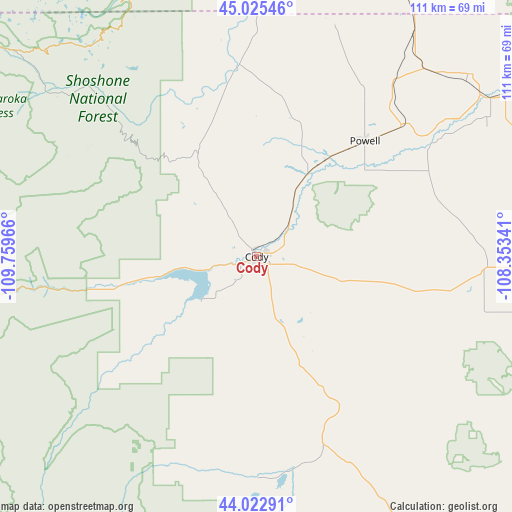
Cody GPS coordinates[2]
44° 31' 34.824" North, 109° 3' 23.508" West
| Map corner | latitude | longitude |
|---|---|---|
| Upper-left | 45.02546°, | -109.75966° |
| Center: | 44.52634°, | -109.05653° |
| Lower-right: | 44.02291°, | -108.35341° |
| Map W x H: | 111.5×111.5 km | = 69.3×69.3mi |
| max Lat: | 71.29058° ⇑9.4% North |
| Cody: | 44.52634° |
| min Lat: | ⇓90.6% South 19.06759° |
| min Long | Cody | max Long |
| -171.73463° | -109.05653° | -66.98998° |
| W 14.6%⇐ | ⇒85.4% E |
Elevation
Elevation of Cody is 1525 m = 5003 ft, and this is 1230.2 m = 4036 ft above average elevation for this country.
| Max E: |
3189 m = 10463 ft | 3.1% |
| Cody | 1525 m 5003 ft | |
| Avg. | 294.8 m = 967 ft | |
Min E: |
-60 m = -197 ft | 96.9% |
See also: United States elevation on elevation.city.
Geographical zone
Cody is located in North temperate zone (between Tropic of Cancer and the Arctic Circle). Distance of this Northern Tropic circle is 2344.9 km =1457.1 mi to South.| Distance of | km | miles | from Cody |
|---|---|---|---|
| North Pole | 5056.2 | 3141.8 | to North |
| Arctic Circle | 2450.3 | 1522.5 | to North |
| Tropic Cancer | 2344.9 | 1457.1 | to South |
| Equator | 4950.9 | 3076.3 | to South |


Nearby cities:
15 places around Cody: (largest is in red/bold)
• Absarokee
114.6 km =71.2 mi,  344°
344°
• Basin
82.4 km =51.2 mi,  101°
101°
• Bridger
86.3 km =53.6 mi,  7°
7°
• Byron
52.9 km =32.9 mi,  55°
55°
• Cowley
61 km =37.9 mi,  49°
49°
• Greybull
79.4 km =49.3 mi,  92°
92°
• Joliet
106.8 km =66.4 mi,  3°
3°
• Lovell
63.1 km =39.2 mi, 56°
• Lucerne
112.6 km =70 mi,  141°
141°
• Powell
34.6 km =21.5 mi,  43°
43°
• Pryor
108.5 km =67.4 mi,  22°
22°
• Red Lodge
74.8 km =46.5 mi,  348°
348°
• Thermopolis
118.9 km =73.9 mi,  145°
145°
• Washakie Ten
103.1 km =64.1 mi,  117°
117°
• Worland
104.4 km =64.9 mi, 122°
Sources, notices
• [Note1] Compared only with cities in United States existing in our database
• [Src1] Map data: © OpenStreetMap contributors (CC-BY-SA)
• [Src2] Other city data from geonames.org with taken over terms of usage.
• [Src3] Geographical zone / Annual Mean Temperature by Robert A. Rohde @ Wikipedia
