Bridger geodata
Bridger (Montana) is a populated place; located in United States in America/Denver (GMT-6) time zone. With population of 729 people, there are 18409 cities with bigger population in this country. Compared to other cities in United States, 93.4% of cities are located further ↓South; 85.4% of cities are located further →East and 94.1% of cities have lower elevation than Bridger. Note1


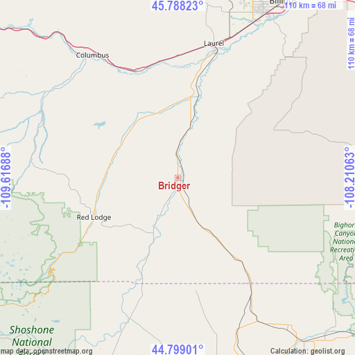
Bridger GPS coordinates[2]
45° 17' 44.808" North, 108° 54' 49.5" West
| Map corner | latitude | longitude |
|---|---|---|
| Upper-left | 45.78823°, | -109.61688° |
| Center: | 45.29578°, | -108.91375° |
| Lower-right: | 44.79901°, | -108.21063° |
| Map W x H: | 110×110 km | = 68.4×68.4mi |
| max Lat: | 71.29058° ⇑6.6% North |
| Bridger: | 45.29578° |
| min Lat: | ⇓93.4% South 19.06759° |
| min Long | Bridger | max Long |
| -171.73463° | -108.91375° | -66.98998° |
| W 14.6%⇐ | ⇒85.4% E |
Elevation
Elevation of Bridger is 1119 m = 3671 ft, and this is 824.2 m = 2704 ft above average elevation for this country.
| Max E: |
3189 m = 10463 ft | 5.9% |
| Bridger | 1119 m 3671 ft | |
| Avg. | 294.8 m = 967 ft | |
Min E: |
-60 m = -197 ft | 94.1% |
See also: United States elevation on elevation.city.
Geographical zone
Bridger is located in North temperate zone (between Tropic of Cancer and the Arctic Circle). Distance of this North polar circle is 2364.8 km =1469.4 mi to North.| Distance of | km | miles | from Bridger |
|---|---|---|---|
| North Pole | 4970.6 | 3088.6 | to North |
| Arctic Circle | 2364.8 | 1469.4 | to North |
| Tropic Cancer | 2430.5 | 1510.2 | to South |
| Equator | 5036.4 | 3129.5 | to South |


Nearby cities:
15 places around Bridger: (largest is in red/bold)
• Absarokee
48.3 km =30 mi,  301°
301°
• Billings
63 km =39.1 mi,  30°
30°
• Byron
64.1 km =39.8 mi,  150°
150°
• Cody
86.3 km =53.6 mi,  187°
187°
• Columbus
46.2 km =28.7 mi,  325°
325°
• Cowley
57.6 km =35.8 mi,  142°
142°
• Joliet
21.5 km =13.4 mi,  348°
348°
• Laurel
43 km =26.7 mi,  14°
14°
• Lockwood
70 km =43.5 mi, 33°
• Lovell
65.5 km =40.7 mi, 141°
• Park City
37.5 km =23.3 mi,  359°
359°
• Powell
61.5 km =38.2 mi,  168°
168°
• Pryor
33.2 km =20.6 mi,  63°
63°
• Red Lodge
28.8 km =17.9 mi,  244°
244°
• Shepherd
84.6 km =52.6 mi, 31°
Sources, notices
• [Note1] Compared only with cities in United States existing in our database
• [Src1] Map data: © OpenStreetMap contributors (CC-BY-SA)
• [Src2] Other city data from geonames.org with taken over terms of usage.
• [Src3] Geographical zone / Annual Mean Temperature by Robert A. Rohde @ Wikipedia
