Red Lodge geodata
Red Lodge (Montana) is a seat of a second-order administrative division; located in United States in America/Denver (GMT-6) time zone. With population of 2,222 people, there are 11287 cities with bigger population in this country. Compared to other cities in United States, 93.2% of cities are located further ↓South; 85.5% of cities are located further →East and 97.9% of cities have lower elevation than Red Lodge. Note1


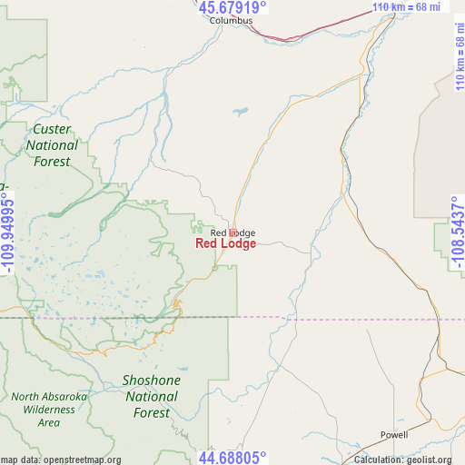
Red Lodge GPS coordinates[2]
45° 11' 8.808" North, 109° 14' 48.552" West
| Map corner | latitude | longitude |
|---|---|---|
| Upper-left | 45.67919°, | -109.94995° |
| Center: | 45.18578°, | -109.24682° |
| Lower-right: | 44.68805°, | -108.5437° |
| Map W x H: | 110.2×110.2 km | = 68.5×68.5mi |
| max Lat: | 71.29058° ⇑6.8% North |
| Red Lodge: | 45.18578° |
| min Lat: | ⇓93.2% South 19.06759° |
| min Long | Red Lodge | max Long |
| -171.73463° | -109.24682° | -66.98998° |
| W 14.5%⇐ | ⇒85.5% E |
Elevation
Elevation of Red Lodge is 1698 m = 5571 ft, and this is 1403.2 m = 4604 ft above average elevation for this country.
| Max E: |
3189 m = 10463 ft | 2.1% |
| Red Lodge | 1698 m 5571 ft | |
| Avg. | 294.8 m = 967 ft | |
Min E: |
-60 m = -197 ft | 97.9% |
See also: United States elevation on elevation.city.
Geographical zone
Red Lodge is located in North temperate zone (between Tropic of Cancer and the Arctic Circle). Distance of this North polar circle is 2377 km =1477 mi to North.| Distance of | km | miles | from Red Lodge |
|---|---|---|---|
| North Pole | 4982.9 | 3096.2 | to North |
| Arctic Circle | 2377 | 1477 | to North |
| Tropic Cancer | 2418.3 | 1502.7 | to South |
| Equator | 5024.2 | 3121.9 | to South |


Nearby cities:
15 places around Red Lodge: (largest is in red/bold)
• Absarokee
40.2 km =25 mi,  337°
337°
• Big Timber
90.9 km =56.5 mi,  322°
322°
• Billings
88.3 km =54.9 mi,  41°
41°
• Bridger
28.8 km =17.9 mi,  64°
64°
• Byron
72.6 km =45.1 mi,  126°
126°
• Cody
74.8 km =46.5 mi,  168°
168°
• Columbus
50.1 km =31.1 mi,  359°
359°
• Cowley
69.7 km =43.3 mi,  118°
118°
• Joliet
39.7 km =24.7 mi,  32°
32°
• Laurel
65.3 km =40.6 mi, 34°
• Lockwood
95.7 km =59.5 mi, 42°
• Lovell
77.7 km =48.3 mi, 119°
• Park City
55.9 km =34.7 mi, 27°
• Powell
61.6 km =38.3 mi,  141°
141°
• Pryor
62 km =38.5 mi, 64°
Sources, notices
• [Note1] Compared only with cities in United States existing in our database
• [Src1] Map data: © OpenStreetMap contributors (CC-BY-SA)
• [Src2] Other city data from geonames.org with taken over terms of usage.
• [Src3] Geographical zone / Annual Mean Temperature by Robert A. Rohde @ Wikipedia
