Brittany Farms-Highlands geodata
Brittany Farms-Highlands (Pennsylvania) is a populated place; located in United States in America/New_York (GMT-4) time zone. With population of 3,695 people, there are 8597 cities with bigger population in this country. Compared to other cities in United States, 56.2% of cities are located further ↓South; 86.7% of cities are located further ←West and 65.5% of cities have higher elevation than Brittany Farms-Highlands. Note1
Administrative division(s):
- Level 1: Pennsylvania
- Level 2: Bucks County
- Level 3: Township of New Britain
Current local time in Brittany Farms-Highlands:
09:03 AM, FridayDifference from your time zone: hours


Brittany Farms-Highlands GPS coordinates[2]
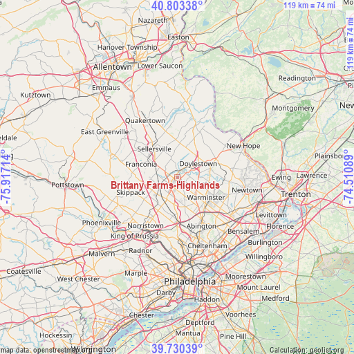
40° 16' 8.436" North, 75° 12' 50.436" West
| Map corner | latitude | longitude |
|---|---|---|
| Upper-left | 40.80338°, | -75.91714° |
| Center: | 40.26901°, | -75.21401° |
| Lower-right: | 39.73039°, | -74.51089° |
| Map W x H: | 119.3×119.3 km | = 74.1×74.1mi |
| max Lat: | 71.29058° ⇑43.8% North |
| Brittany Farms-Highlands: | 40.26901° |
| min Lat: | ⇓56.2% South 19.06759° |
| min Long | Brittany Farms- | max Long |
| -171.73463° | -75.21401° | -66.98998° |
| W 86.7%⇐ | ⇒13.3% E |
Elevation
Elevation of Brittany Farms-Highlands is 126 m = 413 ft, and this is 168.8 m = 554 ft below average elevation for this country.
| Max E: |
3189 m = 10463 ft | 65.5% |
| Avg. | 294.8 m = 967 ft | |
| Brittany Farms-Highlands | 126 m = 413 ft | |
Min E: |
-60 m = -197 ft | 34.5% |
See also: United States elevation on elevation.city.
Geographical zone
Brittany Farms-Highlands is located in North temperate zone (between Tropic of Cancer and the Arctic Circle). Distance of this Northern Tropic circle is 1871.6 km =1163 mi to South.| Distance of | km | miles | from Brittany Farms-Highlands |
|---|---|---|---|
| North Pole | 5529.6 | 3435.9 | to North |
| Arctic Circle | 2923.7 | 1816.7 | to North |
| Tropic Cancer | 1871.6 | 1163 | to South |
| Equator | 4477.5 | 2782.2 | to South |


Nearby cities:
15 places around Brittany Farms-Highlands: (largest is in red/bold)
• Chalfont
2.2 km =1.4 mi,  10°
10°
• Doylestown
8.5 km =5.3 mi,  57°
57°
• Dublin
11.5 km =7.1 mi, 5°
• Hatfield
7.3 km =4.5 mi,  279°
279°
• Kulpsville
10.8 km =6.7 mi,  254°
254°
• Lansdale
6.7 km =4.2 mi,  242°
242°
• Maple Glen
10.4 km =6.5 mi,  164°
164°
• Montgomeryville
3.5 km =2.2 mi,  226°
226°
• New Britain
4.4 km =2.7 mi,  40°
40°
• North Wales
8.4 km =5.2 mi,  220°
220°
• Sellersville
12.2 km =7.6 mi,  320°
320°
• Silverdale
10 km =6.2 mi,  331°
331°
• Souderton
10.6 km =6.6 mi,  296°
296°
• Spring House
9.4 km =5.8 mi,  187°
187°
• Telford
11.3 km =7 mi, 301°
Sources, notices
• [Note1] Compared only with cities in United States existing in our database
• [Src1] Map data: © OpenStreetMap contributors (CC-BY-SA)
• [Src2] Other city data from geonames.org with taken over terms of usage.
• [Src3] Geographical zone / Annual Mean Temperature by Robert A. Rohde @ Wikipedia
