Lansdale geodata
Lansdale (Pennsylvania) is a populated place; located in United States in America/New_York (GMT-4) time zone. With population of 16,512 people, there are 2975 cities with bigger population in this country. Compared to other cities in United States, 56% of cities are located further ↓South; 86.4% of cities are located further ←West and 68.3% of cities have higher elevation than Lansdale. Note1
Administrative division(s):
- Level 1: Pennsylvania
- Level 2: Montgomery County
- Level 3: Borough of Lansdale


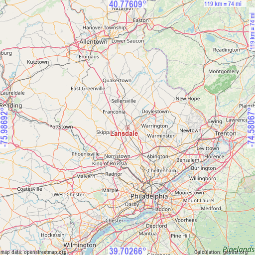
Lansdale GPS coordinates[2]
40° 14' 29.4" North, 75° 17' 1.644" West
| Map corner | latitude | longitude |
|---|---|---|
| Upper-left | 40.77609°, | -75.98692° |
| Center: | 40.2415°, | -75.28379° |
| Lower-right: | 39.70266°, | -74.58067° |
| Map W x H: | 119.4×119.4 km | = 74.2×74.2mi |
| max Lat: | 71.29058° ⇑44% North |
| Lansdale: | 40.2415° |
| min Lat: | ⇓56% South 19.06759° |
| min Long | Lansdale | max Long |
| -171.73463° | -75.28379° | -66.98998° |
| W 86.4%⇐ | ⇒13.6% E |
Elevation
Elevation of Lansdale is 111 m = 364 ft, and this is 183.8 m = 603 ft below average elevation for this country.
| Max E: |
3189 m = 10463 ft | 68.3% |
| Avg. | 294.8 m = 967 ft | |
| Lansdale | 111 m = 364 ft | |
Min E: |
-60 m = -197 ft | 31.7% |
See also: United States elevation on elevation.city.
Geographical zone
Lansdale is located in North temperate zone (between Tropic of Cancer and the Arctic Circle). Distance of this Northern Tropic circle is 1868.5 km =1161 mi to South.| Distance of | km | miles | from Lansdale |
|---|---|---|---|
| North Pole | 5532.6 | 3437.8 | to North |
| Arctic Circle | 2926.7 | 1818.6 | to North |
| Tropic Cancer | 1868.5 | 1161 | to South |
| Equator | 4474.4 | 2780.3 | to South |


Nearby cities:
15 places around Lansdale: (largest is in red/bold)
• Ambler
11 km =6.8 mi,  151°
151°
• Blue Bell
10 km =6.2 mi,  171°
171°
• Brittany Farms-Highlands
6.7 km =4.2 mi,  62°
62°
• Chalfont
8.2 km =5.1 mi,  50°
50°
• Harleysville
9.7 km =6 mi,  295°
295°
• Hatfield
4.5 km =2.8 mi,  342°
342°
• Kulpsville
4.5 km =2.8 mi,  271°
271°
• Maple Glen
11.2 km =7 mi,  128°
128°
• Montgomeryville
3.5 km =2.2 mi,  79°
79°
• New Britain
10.8 km =6.7 mi, 53°
• North Wales
3.4 km =2.1 mi, 172°
• Skippack
10 km =6.2 mi,  258°
258°
• Souderton
8.6 km =5.3 mi, 335°
• Spring House
7.8 km =4.8 mi,  142°
142°
• Telford
9.7 km =6 mi, 337°
Sources, notices
• [Note1] Compared only with cities in United States existing in our database
• [Src1] Map data: © OpenStreetMap contributors (CC-BY-SA)
• [Src2] Other city data from geonames.org with taken over terms of usage.
• [Src3] Geographical zone / Annual Mean Temperature by Robert A. Rohde @ Wikipedia
