Mount Gay-Shamrock geodata
Mount Gay-Shamrock (West Virginia) is a populated place; located in United States in America/New_York (GMT-4) time zone. With population of 1,779 people, there are 12629 cities with bigger population in this country. Compared to other cities in United States, 62.4% of cities are located further ↑North; 65.4% of cities are located further ←West and 76.9% of cities have lower elevation than Mount Gay-Shamrock. Note1


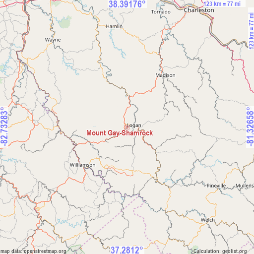
Mount Gay-Shamrock GPS coordinates[2]
37° 50' 18.852" North, 82° 1' 46.92" West
| Map corner | latitude | longitude |
|---|---|---|
| Upper-left | 38.39176°, | -82.73283° |
| Center: | 37.83857°, | -82.0297° |
| Lower-right: | 37.2812°, | -81.32658° |
| Map W x H: | 123.5×123.5 km | = 76.7×76.7mi |
| max Lat: | 71.29058° ⇑62.4% North |
| Mount Gay-Shamrock: | 37.83857° |
| min Lat: | ⇓37.6% South 19.06759° |
| min Long | Mount Gay-Shamr | max Long |
| -171.73463° | -82.0297° | -66.98998° |
| W 65.4%⇐ | ⇒34.6% E |
Elevation
Elevation of Mount Gay-Shamrock is 327 m = 1073 ft, and this is 32.2 m = 106 ft above average elevation for this country.
| Max E: |
3189 m = 10463 ft | 23.1% |
| Mount Gay-Shamrock | 327 m 1073 ft | |
| Avg. | 294.8 m = 967 ft | |
Min E: |
-60 m = -197 ft | 76.9% |
See also: United States elevation on elevation.city.
Geographical zone
Mount Gay-Shamrock is located in North temperate zone (between Tropic of Cancer and the Arctic Circle). Distance of this Northern Tropic circle is 1601.3 km =995 mi to South.| Distance of | km | miles | from Mount Gay-Shamrock |
|---|---|---|---|
| North Pole | 5799.8 | 3603.8 | to North |
| Arctic Circle | 3193.9 | 1984.6 | to North |
| Tropic Cancer | 1601.3 | 995 | to South |
| Equator | 4207.3 | 2614.3 | to South |


Nearby cities:
15 places around Mount Gay-Shamrock: (largest is in red/bold)
• Accoville
18.6 km =11.6 mi,  114°
114°
• Bruno
21.7 km =13.5 mi,  139°
139°
• Chapmanville
15.1 km =9.4 mi,  4°
4°
• Delbarton
19.7 km =12.2 mi,  223°
223°
• Harts
23.1 km =14.4 mi,  337°
337°
• Holden
3.1 km =1.9 mi,  238°
238°
• Kistler
17.5 km =10.9 mi,  121°
121°
• Logan
3.4 km =2.1 mi,  70°
70°
• Mallory
20.7 km =12.9 mi,  125°
125°
• Man
17.3 km =10.7 mi, 129°
• McConnell
5.7 km =3.5 mi,  104°
104°
• Omar
9.6 km =6 mi,  163°
163°
• Robinette
21.6 km =13.4 mi, 106°
• Switzer
6.3 km =3.9 mi, 143°
• Verdunville
2.3 km =1.4 mi,  286°
286°
Sources, notices
• [Note1] Compared only with cities in United States existing in our database
• [Src1] Map data: © OpenStreetMap contributors (CC-BY-SA)
• [Src2] Other city data from geonames.org with taken over terms of usage.
• [Src3] Geographical zone / Annual Mean Temperature by Robert A. Rohde @ Wikipedia
