Harts geodata
Harts (West Virginia) is a populated place; located in United States in America/New_York (GMT-4) time zone. With population of 656 people, there are 19123 cities with bigger population in this country. Compared to other cities in United States, 61.4% of cities are located further ↑North; 65.1% of cities are located further ←West and 51.6% of cities have higher elevation than Harts. Note1


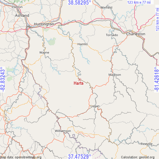
Harts GPS coordinates[2]
38° 1' 52.356" North, 82° 7' 45.48" West
| Map corner | latitude | longitude |
|---|---|---|
| Upper-left | 38.58295°, | -82.83243° |
| Center: | 38.03121°, | -82.1293° |
| Lower-right: | 37.47529°, | -81.42618° |
| Map W x H: | 123.2×123.2 km | = 76.6×76.6mi |
| max Lat: | 71.29058° ⇑61.4% North |
| Harts: | 38.03121° |
| min Lat: | ⇓38.6% South 19.06759° |
| min Long | Harts | max Long |
| -171.73463° | -82.1293° | -66.98998° |
| W 65.1%⇐ | ⇒34.9% E |
Elevation
Elevation of Harts is 192 m = 630 ft, and this is 102.8 m = 337 ft below average elevation for this country.
| Max E: |
3189 m = 10463 ft | 51.6% |
| Avg. | 294.8 m = 967 ft | |
| Harts | 192 m = 630 ft | |
Min E: |
-60 m = -197 ft | 48.4% |
See also: United States elevation on elevation.city.
Geographical zone
Harts is located in North temperate zone (between Tropic of Cancer and the Arctic Circle). Distance of this Northern Tropic circle is 1622.8 km =1008.4 mi to South.| Distance of | km | miles | from Harts |
|---|---|---|---|
| North Pole | 5778.4 | 3590.5 | to North |
| Arctic Circle | 3172.5 | 1971.3 | to North |
| Tropic Cancer | 1622.8 | 1008.4 | to South |
| Equator | 4228.7 | 2627.6 | to South |


Nearby cities:
15 places around Harts: (largest is in red/bold)
• Chapmanville
11.7 km =7.3 mi,  123°
123°
• Danville
26.4 km =16.4 mi,  77°
77°
• Delbarton
36 km =22.4 mi,  187°
187°
• Hamlin
27.6 km =17.1 mi,  4°
4°
• Holden
23.8 km =14.8 mi,  165°
165°
• Kistler
38.6 km =24 mi,  142°
142°
• Logan
23.5 km =14.6 mi,  149°
149°
• Madison
27.4 km =17 mi, 81°
• McConnell
26.9 km =16.7 mi, 148°
• Mount Gay-Shamrock
23.1 km =14.4 mi,  157°
157°
• Omar
32.7 km =20.3 mi, 159°
• Switzer
29.2 km =18.1 mi, 154°
• Verdunville
21.7 km =13.5 mi, 162°
• Wayne
34.6 km =21.5 mi,  307°
307°
• West Hamlin
28.9 km =18 mi,  348°
348°
Sources, notices
• [Note1] Compared only with cities in United States existing in our database
• [Src1] Map data: © OpenStreetMap contributors (CC-BY-SA)
• [Src2] Other city data from geonames.org with taken over terms of usage.
• [Src3] Geographical zone / Annual Mean Temperature by Robert A. Rohde @ Wikipedia
