Emerald Mountain geodata
Emerald Mountain (Alabama) is a populated place; located in United States in America/Chicago (GMT-5) time zone. With population of 2,561 people, there are 10475 cities with bigger population in this country. Compared to other cities in United States, 87.3% of cities are located further ↑North; 52.7% of cities are located further ←West and 69.1% of cities have higher elevation than Emerald Mountain. Note1


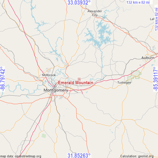
Emerald Mountain GPS coordinates[2]
32° 26' 52.548" North, 86° 5' 39.444" West
| Map corner | latitude | longitude |
|---|---|---|
| Upper-left | 33.03932°, | -86.79742° |
| Center: | 32.44793°, | -86.09429° |
| Lower-right: | 31.85263°, | -85.39117° |
| Map W x H: | 131.9×131.9 km | = 82×82mi |
| max Lat: | 71.29058° ⇑87.3% North |
| Emerald Mountain: | 32.44793° |
| min Lat: | ⇓12.7% South 19.06759° |
| min Long | Emerald Mountai | max Long |
| -171.73463° | -86.09429° | -66.98998° |
| W 52.7%⇐ | ⇒47.3% E |
Elevation
Elevation of Emerald Mountain is 106 m = 348 ft, and this is 188.8 m = 619 ft below average elevation for this country.
| Max E: |
3189 m = 10463 ft | 69.1% |
| Avg. | 294.8 m = 967 ft | |
| Emerald Mountain | 106 m = 348 ft | |
Min E: |
-60 m = -197 ft | 30.9% |
See also: United States elevation on elevation.city.
Geographical zone
Emerald Mountain is located in North temperate zone (between Tropic of Cancer and the Arctic Circle). Distance of this Northern Tropic circle is 1002 km =622.6 mi to South.| Distance of | km | miles | from Emerald Mountain |
|---|---|---|---|
| North Pole | 6399.2 | 3976.3 | to North |
| Arctic Circle | 3793.3 | 2357 | to North |
| Tropic Cancer | 1002 | 622.6 | to South |
| Equator | 3607.9 | 2241.8 | to South |


Nearby cities:
15 places around Emerald Mountain: (largest is in red/bold)
• Blue Ridge
10.3 km =6.4 mi,  298°
298°
• Coosada
22.9 km =14.2 mi,  284°
284°
• Deatsville
33.4 km =20.8 mi, 302°
• Eclectic
21.6 km =13.4 mi,  15°
15°
• Elmore
23 km =14.3 mi, 296°
• Holtville
30.2 km =18.8 mi,  313°
313°
• Matthews
22 km =13.7 mi,  157°
157°
• Millbrook
25.4 km =15.8 mi, 278°
• Montgomery
21.3 km =13.2 mi,  244°
244°
• Pike Road
18.2 km =11.3 mi,  182°
182°
• Prattville
34.3 km =21.3 mi,  272°
272°
• Reeltown
32.2 km =20 mi,  57°
57°
• Tallassee
21.2 km =13.2 mi, 62°
• Tuskegee
37.9 km =23.5 mi,  93°
93°
• Wetumpka
15.3 km =9.5 mi, 314°
Sources, notices
• [Note1] Compared only with cities in United States existing in our database
• [Src1] Map data: © OpenStreetMap contributors (CC-BY-SA)
• [Src2] Other city data from geonames.org with taken over terms of usage.
• [Src3] Geographical zone / Annual Mean Temperature by Robert A. Rohde @ Wikipedia
