Eclectic geodata
Eclectic (Alabama) is a populated place; located in United States in America/Chicago (GMT-5) time zone. With population of 1,029 people, there are 16082 cities with bigger population in this country. Compared to other cities in United States, 86.6% of cities are located further ↑North; 52.8% of cities are located further ←West and 55.3% of cities have higher elevation than Eclectic. Note1


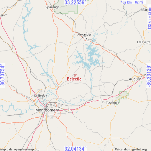
Eclectic GPS coordinates[2]
32° 38' 7.476" North, 86° 2' 3.876" West
| Map corner | latitude | longitude |
|---|---|---|
| Upper-left | 33.22556°, | -86.73754° |
| Center: | 32.63541°, | -86.03441° |
| Lower-right: | 32.04134°, | -85.33129° |
| Map W x H: | 131.7×131.7 km | = 81.8×81.8mi |
| max Lat: | 71.29058° ⇑86.6% North |
| Eclectic: | 32.63541° |
| min Lat: | ⇓13.4% South 19.06759° |
| min Long | Eclectic | max Long |
| -171.73463° | -86.03441° | -66.98998° |
| W 52.8%⇐ | ⇒47.2% E |
Elevation
Elevation of Eclectic is 179 m = 587 ft, and this is 115.8 m = 380 ft below average elevation for this country.
| Max E: |
3189 m = 10463 ft | 55.3% |
| Avg. | 294.8 m = 967 ft | |
| Eclectic | 179 m = 587 ft | |
Min E: |
-60 m = -197 ft | 44.7% |
See also: United States elevation on elevation.city.
Geographical zone
Eclectic is located in North temperate zone (between Tropic of Cancer and the Arctic Circle). Distance of this Northern Tropic circle is 1022.8 km =635.5 mi to South.| Distance of | km | miles | from Eclectic |
|---|---|---|---|
| North Pole | 6378.3 | 3963.3 | to North |
| Arctic Circle | 3772.5 | 2344.1 | to North |
| Tropic Cancer | 1022.8 | 635.5 | to South |
| Equator | 3628.7 | 2254.8 | to South |


Nearby cities:
15 places around Eclectic: (largest is in red/bold)
• Blue Ridge
21.6 km =13.4 mi,  222°
222°
• Coosada
31.7 km =19.7 mi,  241°
241°
• Dadeville
33.4 km =20.8 mi,  49°
49°
• Deatsville
34 km =21.1 mi,  264°
264°
• Elmore
28.4 km =17.6 mi,  247°
247°
• Emerald Mountain
21.6 km =13.4 mi,  195°
195°
• Hissop
30.7 km =19.1 mi,  338°
338°
• Holtville
27.4 km =17 mi,  270°
270°
• Jacksons Gap
34.8 km =21.6 mi,  36°
36°
• Notasulga
34.9 km =21.7 mi,  103°
103°
• Our Town
22.5 km =14 mi,  17°
17°
• Reeltown
21.7 km =13.5 mi, 99°
• Rockford
33.1 km =20.6 mi,  328°
328°
• Tallassee
17.2 km =10.7 mi,  129°
129°
• Wetumpka
19.5 km =12.1 mi, 238°
Sources, notices
• [Note1] Compared only with cities in United States existing in our database
• [Src1] Map data: © OpenStreetMap contributors (CC-BY-SA)
• [Src2] Other city data from geonames.org with taken over terms of usage.
• [Src3] Geographical zone / Annual Mean Temperature by Robert A. Rohde @ Wikipedia
