Lakewood geodata
Lakewood (Colorado) is a populated place; located in United States in America/Denver (GMT-6) time zone. With population of 152,597 people, there are 189 cities with bigger population in this country. Compared to other cities in United States, 50.7% of cities are located further ↓South; 83.4% of cities are located further →East and 97.8% of cities have lower elevation than Lakewood. Note1


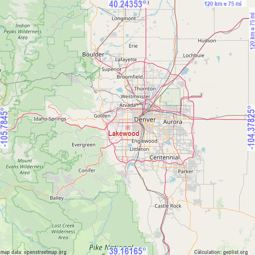
Lakewood GPS coordinates[2]
39° 42' 16.956" North, 105° 4' 52.932" West
| Map corner | latitude | longitude |
|---|---|---|
| Upper-left | 40.24353°, | -105.7845° |
| Center: | 39.70471°, | -105.08137° |
| Lower-right: | 39.16165°, | -104.37825° |
| Map W x H: | 120.3×120.3 km | = 74.8×74.8mi |
| max Lat: | 71.29058° ⇑49.3% North |
| Lakewood: | 39.70471° |
| min Lat: | ⇓50.7% South 19.06759° |
| min Long | Lakewood | max Long |
| -171.73463° | -105.08137° | -66.98998° |
| W 16.6%⇐ | ⇒83.4% E |
Elevation
Elevation of Lakewood is 1682 m = 5518 ft, and this is 1387.2 m = 4551 ft above average elevation for this country.
| Max E: |
3189 m = 10463 ft | 2.2% |
| Lakewood | 1682 m 5518 ft | |
| Avg. | 294.8 m = 967 ft | |
Min E: |
-60 m = -197 ft | 97.8% |
See also: Lakewood elevation on elevation.city.
Geographical zone
Lakewood is located in North temperate zone (between Tropic of Cancer and the Arctic Circle). Distance of this Northern Tropic circle is 1808.8 km =1123.9 mi to South.| Distance of | km | miles | from Lakewood |
|---|---|---|---|
| North Pole | 5592.3 | 3474.9 | to North |
| Arctic Circle | 2986.4 | 1855.7 | to North |
| Tropic Cancer | 1808.8 | 1123.9 | to South |
| Equator | 4414.7 | 2743.2 | to South |


Nearby cities:
15 places around Lakewood: (largest is in red/bold)
• Applewood
9.1 km =5.7 mi,  310°
310°
• Arvada
10.9 km =6.8 mi,  357°
357°
• Berkley
12.1 km =7.5 mi,  23°
23°
• Bow Mar
8.9 km =5.5 mi,  162°
162°
• Cherry Hills Village
12.6 km =7.8 mi,  123°
123°
• Columbine Valley
12.3 km =7.6 mi, 159°
• Denver
9.1 km =5.7 mi,  65°
65°
• Edgewater
5.6 km =3.5 mi, 15°
• Englewood
10.2 km =6.3 mi,  128°
128°
• Glendale
12.6 km =7.8 mi,  89°
89°
• Littleton
11.6 km =7.2 mi,  151°
151°
• Mountain View
8.1 km =5 mi, 15°
• Sheridan
8 km =5 mi,  143°
143°
• West Pleasant View
8.9 km =5.5 mi,  290°
290°
• Wheat Ridge
6.8 km =4.2 mi,  2°
2°
Sources, notices
• [Note1] Compared only with cities in United States existing in our database
• [Src1] Map data: © OpenStreetMap contributors (CC-BY-SA)
• [Src2] Other city data from geonames.org with taken over terms of usage.
• [Src3] Geographical zone / Annual Mean Temperature by Robert A. Rohde @ Wikipedia
