West Pleasant View geodata
West Pleasant View (Colorado) is a populated place; located in United States in America/Denver (GMT-6) time zone. With population of 3,840 people, there are 8408 cities with bigger population in this country. Compared to other cities in United States, 50.9% of cities are located further ↓South; 83.5% of cities are located further →East and 98.3% of cities have lower elevation than West Pleasant View. Note1


West Pleasant View GPS coordinates[2]
39° 43' 57.216" North, 105° 10' 42.672" West
| Map corner | latitude | longitude |
|---|---|---|
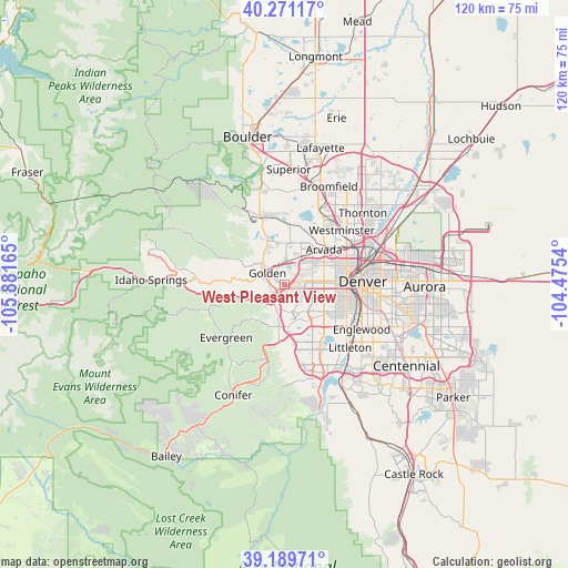
| Upper-left | 40.27117°, | -105.88165° |
| Center: | 39.73256°, | -105.17852° |
| Lower-right: | 39.18971°, | -104.4754° |
| Map W x H: | 120.2×120.2 km | = 74.7×74.7mi |
| max Lat: | 71.29058° ⇑49.1% North |
| West Pleasant View: | 39.73256° |
| min Lat: | ⇓50.9% South 19.06759° |
| min Long | West Pleasant V | max Long |
| -171.73463° | -105.17852° | -66.98998° |
| W 16.5%⇐ | ⇒83.5% E |
Elevation
Elevation of West Pleasant View is 1775 m = 5823 ft, and this is 1480.2 m = 4856 ft above average elevation for this country.
| Max E: |
3189 m = 10463 ft | 1.7% |
| West Pleasant View | 1775 m 5823 ft | |
| Avg. | 294.8 m = 967 ft | |
Min E: |
-60 m = -197 ft | 98.3% |
See also: United States elevation on elevation.city.
Geographical zone
West Pleasant View is located in North temperate zone (between Tropic of Cancer and the Arctic Circle). Distance of this Northern Tropic circle is 1811.9 km =1125.9 mi to South.| Distance of | km | miles | from West Pleasant View |
|---|---|---|---|
| North Pole | 5589.2 | 3473 | to North |
| Arctic Circle | 2983.3 | 1853.7 | to North |
| Tropic Cancer | 1811.9 | 1125.9 | to South |
| Equator | 4417.8 | 2745.1 | to South |


Nearby cities:
15 places around West Pleasant View: (largest is in red/bold)
• Applewood
3.1 km =1.9 mi,  26°
26°
• Arvada
11 km =6.8 mi,  44°
44°
• Berkley
15.3 km =9.5 mi,  58°
58°
• Bow Mar
16 km =9.9 mi,  136°
136°
• Denver
16.6 km =10.3 mi,  87°
87°
• Edgewater
10 km =6.2 mi,  76°
76°
• Evergreen
16.2 km =10.1 mi,  227°
227°
• Genesee
9.6 km =6 mi,  237°
237°
• Golden
4.4 km =2.7 mi,  305°
305°
• Indian Hills
13.8 km =8.6 mi,  201°
201°
• Kittredge
13.5 km =8.4 mi, 230°
• Lakewood
8.9 km =5.5 mi,  110°
110°
• Mountain View
11.5 km =7.1 mi,  66°
66°
• Sheridan
16.2 km =10.1 mi,  125°
125°
• Wheat Ridge
9.4 km =5.8 mi, 66°
Sources, notices
• [Note1] Compared only with cities in United States existing in our database
• [Src1] Map data: © OpenStreetMap contributors (CC-BY-SA)
• [Src2] Other city data from geonames.org with taken over terms of usage.
• [Src3] Geographical zone / Annual Mean Temperature by Robert A. Rohde @ Wikipedia
