Old Jamestown geodata
Old Jamestown (Missouri) is a populated place; located in United States in America/Chicago (GMT-5) time zone. With population of 19,184 people, there are 2626 cities with bigger population in this country. Compared to other cities in United States, 56.3% of cities are located further ↑North; 59.9% of cities are located further →East and 56.6% of cities have higher elevation than Old Jamestown. Note1
Administrative division(s):
- Level 1: Missouri
- Level 2: Saint Louis County
- Level 3: Township of Spanish Lake


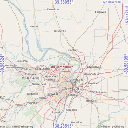
Old Jamestown GPS coordinates[2]
38° 50' 5.784" North, 90° 17' 6.396" West
| Map corner | latitude | longitude |
|---|---|---|
| Upper-left | 39.38053°, | -90.98824° |
| Center: | 38.83494°, | -90.28511° |
| Lower-right: | 38.28513°, | -89.58199° |
| Map W x H: | 121.8×121.8 km | = 75.7×75.7mi |
| max Lat: | 71.29058° ⇑56.3% North |
| Old Jamestown: | 38.83494° |
| min Lat: | ⇓43.7% South 19.06759° |
| min Long | Old Jamestown | max Long |
| -171.73463° | -90.28511° | -66.98998° |
| W 40.1%⇐ | ⇒59.9% E |
Elevation
Elevation of Old Jamestown is 173 m = 568 ft, and this is 121.8 m = 400 ft below average elevation for this country.
| Max E: |
3189 m = 10463 ft | 56.6% |
| Avg. | 294.8 m = 967 ft | |
| Old Jamestown | 173 m = 568 ft | |
Min E: |
-60 m = -197 ft | 43.4% |
See also: United States elevation on elevation.city.
Geographical zone
Old Jamestown is located in North temperate zone (between Tropic of Cancer and the Arctic Circle). Distance of this Northern Tropic circle is 1712.1 km =1063.8 mi to South.| Distance of | km | miles | from Old Jamestown |
|---|---|---|---|
| North Pole | 5689 | 3535 | to North |
| Arctic Circle | 3083.1 | 1915.7 | to North |
| Tropic Cancer | 1712.1 | 1063.8 | to South |
| Equator | 4318 | 2683.1 | to South |


Nearby cities:
15 places around Old Jamestown: (largest is in red/bold)
• Alton
10.7 km =6.6 mi,  54°
54°
• Bellefontaine Neighbors
11.7 km =7.3 mi,  154°
154°
• Berkeley
9.8 km =6.1 mi,  204°
204°
• Black Jack
4.9 km =3 mi,  161°
161°
• Calverton Park
8.2 km =5.1 mi, 197°
• Castle Point
9.1 km =5.7 mi, 159°
• Dellwood
9.5 km =5.9 mi,  180°
180°
• Ferguson
10.2 km =6.3 mi,  189°
189°
• Florissant
6 km =3.7 mi,  212°
212°
• Glasgow Village
11.8 km =7.3 mi,  140°
140°
• Hazelwood
10.3 km =6.4 mi,  226°
226°
• Moline Acres
10.5 km =6.5 mi, 158°
• Riverview
11.6 km =7.2 mi, 146°
• Spanish Lake
8 km =5 mi,  131°
131°
• West Alton
6.4 km =4 mi,  58°
58°
Sources, notices
• [Note1] Compared only with cities in United States existing in our database
• [Src1] Map data: © OpenStreetMap contributors (CC-BY-SA)
• [Src2] Other city data from geonames.org with taken over terms of usage.
• [Src3] Geographical zone / Annual Mean Temperature by Robert A. Rohde @ Wikipedia
