Cordry Sweetwater Lakes geodata
Cordry Sweetwater Lakes (Indiana) is a populated place; located in United States in America/Indiana/Indianapolis (GMT-4) time zone. With population of 1,128 people, there are 15523 cities with bigger population in this country. Compared to other cities in United States, 52.2% of cities are located further ↑North; 52.6% of cities are located further ←West and 69.7% of cities have lower elevation than Cordry Sweetwater Lakes. Note1
Current local time in Cordry Sweetwater Lakes:
10:46 AM, FridayDifference from your time zone: hours


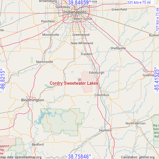
Cordry Sweetwater Lakes GPS coordinates[2]
39° 18' 16.704" North, 86° 7' 6.132" West
| Map corner | latitude | longitude |
|---|---|---|
| Upper-left | 39.84659°, | -86.8215° |
| Center: | 39.30464°, | -86.11837° |
| Lower-right: | 38.75846°, | -85.41525° |
| Map W x H: | 121×121 km | = 75.2×75.2mi |
| max Lat: | 71.29058° ⇑52.2% North |
| Cordry Sweetwater Lakes: | 39.30464° |
| min Lat: | ⇓47.8% South 19.06759° |
| min Long | Cordry Sweetwat | max Long |
| -171.73463° | -86.11837° | -66.98998° |
| W 52.6%⇐ | ⇒47.4% E |
Elevation
Elevation of Cordry Sweetwater Lakes is 284 m = 932 ft, and this is 10.8 m = 35 ft below average elevation for this country.
| Max E: |
3189 m = 10463 ft | 30.3% |
| Avg. | 294.8 m = 967 ft | |
| Cordry Sweetwater Lakes | 284 m = 932 ft | |
Min E: |
-60 m = -197 ft | 69.7% |
See also: United States elevation on elevation.city.
Geographical zone
Cordry Sweetwater Lakes is located in North temperate zone (between Tropic of Cancer and the Arctic Circle). Distance of this Northern Tropic circle is 1764.3 km =1096.3 mi to South.| Distance of | km | miles | from Cordry Sweetwater Lakes |
|---|---|---|---|
| North Pole | 5636.8 | 3502.5 | to North |
| Arctic Circle | 3030.9 | 1883.3 | to North |
| Tropic Cancer | 1764.3 | 1096.3 | to South |
| Equator | 4370.3 | 2715.6 | to South |


Nearby cities:
15 places around Cordry Sweetwater Lakes: (largest is in red/bold)
• Bargersville
24.4 km =15.2 mi,  349°
349°
• Columbus
20.5 km =12.7 mi,  124°
124°
• Edinburgh
14.2 km =8.8 mi,  67°
67°
• Franklin
20.3 km =12.6 mi,  15°
15°
• Hope
29.9 km =18.6 mi,  90°
90°
• Martinsville
30 km =18.6 mi,  297°
297°
• Morgantown
14.3 km =8.9 mi, 301°
• Nashville
15.7 km =9.8 mi,  226°
226°
• New Whiteland
28.3 km =17.6 mi,  4°
4°
• Painted Hills
22 km =13.7 mi, 297°
• Princes Lakes
5.7 km =3.5 mi, 17°
• Taylorsville
14.4 km =8.9 mi, 93°
• Trafalgar
12.7 km =7.9 mi, 347°
• Waterloo
29.5 km =18.3 mi, 346°
• Whiteland
27.5 km =17.1 mi,  6°
6°
Sources, notices
• [Note1] Compared only with cities in United States existing in our database
• [Src1] Map data: © OpenStreetMap contributors (CC-BY-SA)
• [Src2] Other city data from geonames.org with taken over terms of usage.
• [Src3] Geographical zone / Annual Mean Temperature by Robert A. Rohde @ Wikipedia
