Edinburgh geodata
Edinburgh (Indiana) is a populated place; located in United States in America/Indiana/Indianapolis (GMT-4) time zone. With population of 4,546 people, there are 7601 cities with bigger population in this country. Compared to other cities in United States, 51.9% of cities are located further ↑North; 53% of cities are located further ←West and 51.9% of cities have lower elevation than Edinburgh. Note1
Administrative division(s):
- Level 1: Indiana
- Level 2: Johnson County
- Level 3: Township of Blue River


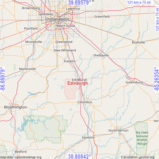
Edinburgh GPS coordinates[2]
39° 21' 15.192" North, 85° 57' 59.976" West
| Map corner | latitude | longitude |
|---|---|---|
| Upper-left | 39.89579°, | -86.66979° |
| Center: | 39.35422°, | -85.96666° |
| Lower-right: | 38.80842°, | -85.26354° |
| Map W x H: | 120.9×120.9 km | = 75.1×75.1mi |
| max Lat: | 71.29058° ⇑51.9% North |
| Edinburgh: | 39.35422° |
| min Lat: | ⇓48.1% South 19.06759° |
| min Long | Edinburgh | max Long |
| -171.73463° | -85.96666° | -66.98998° |
| W 53%⇐ | ⇒47% E |
Elevation
Elevation of Edinburgh is 206 m = 676 ft, and this is 88.8 m = 291 ft below average elevation for this country.
| Max E: |
3189 m = 10463 ft | 48.1% |
| Avg. | 294.8 m = 967 ft | |
| Edinburgh | 206 m = 676 ft | |
Min E: |
-60 m = -197 ft | 51.9% |
See also: United States elevation on elevation.city.
Geographical zone
Edinburgh is located in North temperate zone (between Tropic of Cancer and the Arctic Circle). Distance of this Northern Tropic circle is 1769.9 km =1099.8 mi to South.| Distance of | km | miles | from Edinburgh |
|---|---|---|---|
| North Pole | 5631.3 | 3499.1 | to North |
| Arctic Circle | 3025.4 | 1879.9 | to North |
| Tropic Cancer | 1769.9 | 1099.8 | to South |
| Equator | 4375.8 | 2719 | to South |


Nearby cities:
15 places around Edinburgh: (largest is in red/bold)
• Bargersville
25.3 km =15.7 mi,  317°
317°
• Columbus
17.4 km =10.8 mi,  167°
167°
• Cordry Sweetwater Lakes
14.2 km =8.8 mi,  247°
247°
• Elizabethtown
27.7 km =17.2 mi,  151°
151°
• Fairland
27.2 km =16.9 mi,  18°
18°
• Franklin
16 km =9.9 mi,  331°
331°
• Geneva
21.6 km =13.4 mi,  78°
78°
• Hope
17.7 km =11 mi,  108°
108°
• Morgantown
25.4 km =15.8 mi,  274°
274°
• New Whiteland
25.2 km =15.7 mi, 334°
• Princes Lakes
11.3 km =7 mi, 269°
• Shelbyville
24.7 km =15.3 mi,  41°
41°
• Taylorsville
6.6 km =4.1 mi, 168°
• Trafalgar
17.3 km =10.7 mi,  293°
293°
• Whiteland
23.8 km =14.8 mi,  335°
335°
Sources, notices
• [Note1] Compared only with cities in United States existing in our database
• [Src1] Map data: © OpenStreetMap contributors (CC-BY-SA)
• [Src2] Other city data from geonames.org with taken over terms of usage.
• [Src3] Geographical zone / Annual Mean Temperature by Robert A. Rohde @ Wikipedia
